|
|
|
Home | Forums |
Downloads | Gallery |
News & Articles | Resources |
Jobs | FAQ |
| Join |
Welcome !
|
5 Users Online (3 Members):
Show Users Online
- Most ever was 626 - Mon, Jan 12, 2015 at 2:00:17 PM |
Forums
|
Forums >> Revit Building >> Technical Support >> TOPOGRAPHY - TOPO LINES NOT FOLLOWING SURVEY
|
|
|
active
Joined: Mon, Sep 13, 2004
26 Posts
No Rating |
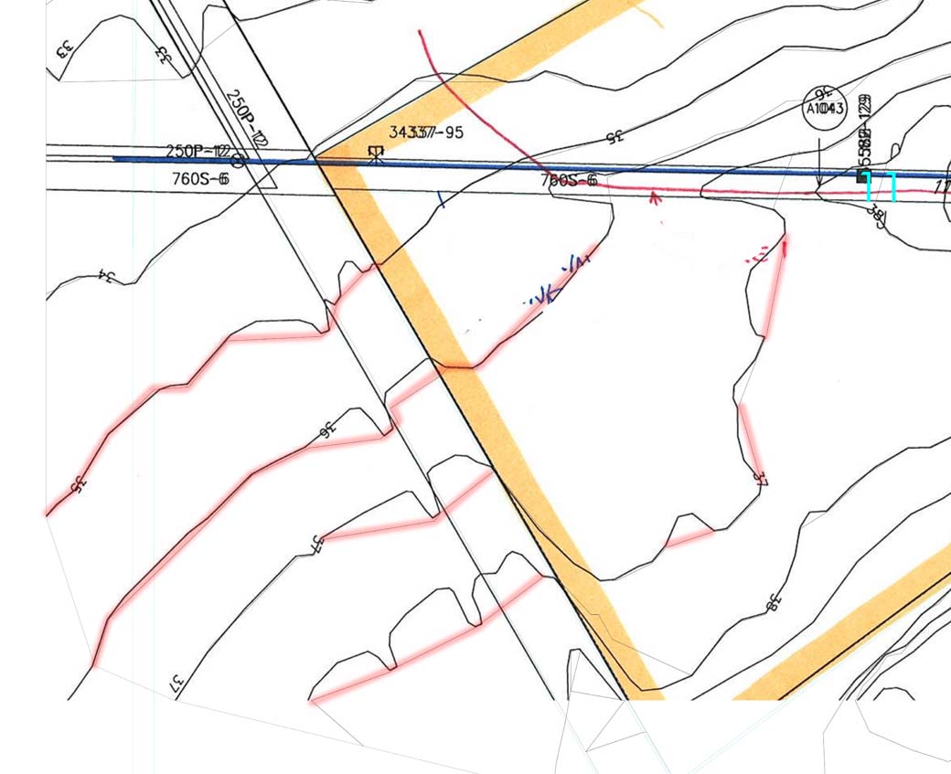
Hey guys, This has been a problem that has been going on for years with revit but I never found a solution. When I create a topo surface (say by tracing a jpeg or dwg) the lines don't always follow where they have appeared in the survey I am tracing (pls see attachment). Does anyone know why this happens and how I can fix it, it is a major problem really cause it makes the site information in your revit model inaccurate and basically useless. The red lines in the file are an overlay over the lines produced by revit. Cheers Scotty V
|
This user is offline |
View Website
|
 | |
|
|
active
Joined: Tue, Oct 18, 2005
45 Posts
 |
Revit is not very good at complex shapes like sites. You just have to keep adding points along the topo lines until they are more or less where you need them to be - you will probably need four or five points on each contour just to get the ditch south of the road.
|
This user is offline |
|
|
|
active
Joined: Tue, Oct 18, 2005
45 Posts
|
Also, sometimes you have to add some extra points off the countour to nudge them back -- perhaps drop a 325.9' point in the ditch near the 326' line, so it doesn' ttry to round off the point of the ditch...
|
This user is offline |
|
|
|
site moderator|||
Joined: Tue, May 16, 2006
13079 Posts
 |
Most topograpy contours are just a best guess and who is to say what is right or wrong as long as they work with the survey points. If your surveyor added points at both sides and the bottom of the ditches, that helps but just like the old days, the draftsman needs to add some "points" to make the contour lines look right.
|
This user is offline |
|
|
|
active
Joined: Wed, Jan 3, 2007
75 Posts
 |
Contour lines are basically just representative interpolations made by a drafter and/or software based on elevation points from a survey. The more elevation points that are generated the more accurate the lines appear to be. There are many posts you can search on this site about this issue; here is one thread you can check out: http://www.revitcity.com/forums.php?action=viewthread&thread_id=5839 HTH.
|
This user is offline |
|
|
|
active
Joined: Mon, Sep 13, 2004
26 Posts
No Rating |
Good points guys thanks for your help.
|
This user is offline |
View Website
|
|
|
Similar Threads |
|
matching contour lines from civil CAD when creating Topography (2019) |
Revit Building >> Technical Support
|
Fri, Dec 4, 2020 at 2:09:46 PM
|
1
|
|
autoCAD Survey Plans to 3D Topo |
Revit Building >> Technical Support
|
Fri, Aug 1, 2008 at 4:12:58 AM
|
3
|
|
Revit 2017 - Topography contour lines visibility |
Revit Building >> Technical Support
|
Wed, May 5, 2021 at 1:55:53 PM
|
8
|
|
topo survey AutoCAD to Revit |
Revit Structure >> Technical Support
|
Thu, Feb 26, 2009 at 11:45:41 AM
|
4
|
|
Topography Elevation from Project Base and Survey Point is Incorrect |
Revit Building >> Technical Support
|
Thu, Jan 29, 2015 at 10:32:24 PM
|
9
|
|
|
Site Stats
Members: | 2161655 | Objects: | 23325 | Forum Posts: | 152479 | Job Listings: | 3 |
|
 Search