Search Gallery
Gallery Favorites
|
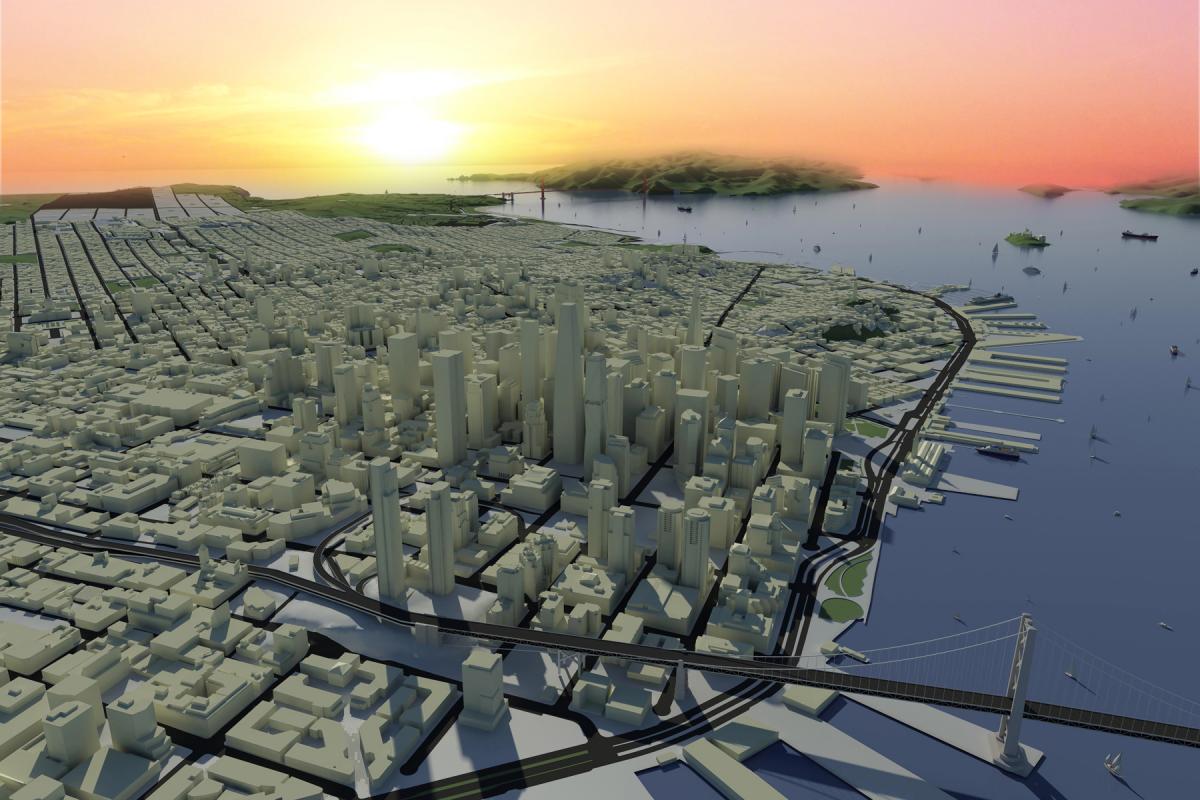
San Francisco City Model
 |
|
View image full size|||

|
 |
|
Uploaded By: colin1182 Thu, Apr 11, 2013
|
|
Description: Built in 15 zones that link together origin to origin. Topo, streets, curbs, lots and property lines came from GIS data. The larger buildings are modeled individually to control visaibility. The single residence smaller buildings were taken from google earth.
This cover the 7 x 7 miles of San Francisco, both the bay bridge and golden gate bridge, north bay, east, bay, Oakland, Alcatraz, Angel Island and Treasure Island.
100% Revit modeled and rendered. Background in Photoshop. This is used by our offce and the city of SF to do shadow studies and skyline studies for new high rises. I built this over the course of 2 years when the economy got real bad after the housing bubble and there wasnt much work, so this was my pass time project.
|
Previous Next |
Comments
|
Fri, Apr 12, 2013 at 12:31:03 AM
#1
|
|
active
Joined Mon, Jun 7, 2010
No rating This user is offline |
wow,
|
|
|
Fri, Apr 12, 2013 at 8:33:01 AM
#2
|
|
active

Joined Sun, Oct 19, 2008
This user is offline |
How much do you want for it? 
|
|
|
Fri, Apr 12, 2013 at 8:38:04 AM
#3
|
|
active

Joined Tue, Mar 10, 2009
 This user is offline |
I remember this one a few years ago. Nice to see it again
|
|
|
Fri, Apr 12, 2013 at 9:08:27 AM
#4
|
|
active
Joined Tue, May 1, 2012
 This user is offline |
perfect...
|
|
|
Fri, Apr 12, 2013 at 9:44:00 AM
#5
|
|
active
Joined Tue, Jun 14, 2011
No rating This user is offline |
I am currently working on an Urban master plan for studio, I have chosen to use revit as my software and I have a similar condition to what you have done with the bridge, can you fill me in on what your strategy was, in revit to build the bridge or an elevated road, I would greatly appreciate your help.
Also, this project looks great!
|
|
|
Fri, Apr 12, 2013 at 7:09:51 PM
#6
|
|
active

Joined Fri, Oct 17, 2008
This user is offline |
Excellent Wow! Great Work!
|
|
|
Fri, Apr 12, 2013 at 10:24:58 PM
#7
|
|
active
Joined Sat, Jun 14, 2008
This user is offline |
This was posted a few years ago, since then I have continually updated buildings to be more accurate in certain zones and areas. I have also added new contruction and proposed buildings and the new height limits for the SOMA area with potential buildings as a result of height limit increases.
This was built in 15 zones that were just topography, then the roads were cut, sidewalks, lots, and property lines. Then I linked the site work into another file where the 3D buildings were placed. From there, I linked all the zones now with nested links containing topo and sitework and now containing the 3D buildings back into one big city model. It is divided into zones for ease of work, and all linked together to create a file that is less than 5MB in size.
The city file has come a long way and been used extensively since I first built it back in 2009 or 2010. We use it for all our local projects at the firm I work for. Unfortunately, it is not for sale as it is the most detailed and extensive computer 3D SF city model in existence and gets used by the city for skyline studies, shadow studies, and wind studies. and it is the property of the firm I work for So no sale, sorry. Everyone must build their own. This is an ever growing project as new highrises go up and the downtown changes and I replace box buildings with more detailed representations of the actual building.
Thanks for the comments!
|
|
|
Sat, Apr 13, 2013 at 7:13:57 AM
#8
|
|
active
Joined Mon, Nov 15, 2010
 This user is offline |
good job dude
|
|
|
Mon, May 6, 2013 at 4:09:00 AM
#9
|
|
active
Joined Fri, Nov 4, 2011
No rating This user is offline |
seriously how much for this!!!
|
|
|
Sun, May 12, 2013 at 5:49:28 PM
#10
|
|
active
Joined Sun, Feb 5, 2012
This user is offline |
WOWWW.... You are too good !!
|
|
|
Site Stats
Members: | 2161655 | Objects: | 23325 | Forum Posts: | 152479 | Job Listings: | 3 |
|
;)