RevitCity.com Logo

Home  |  Forums  |  Downloads  |  Gallery  |  News & Articles  |  Resources  |  Jobs  |  FAQ  |  SearchSearch  |  Join  |  LoginLogin

Welcome !

64 Users Online (63 Members): Show Users Online - Most ever was 626 - Mon, Jan 12, 2015 at 2:00:17 PM


Forums

Forums >> General Discussion >> Revit Project Management >> site map?

Search this ThreadSearch this Thread | Page 1 of 1 |

Wed, Jul 11, 2007 at 4:06:20 PM | site map?

#1

jitsuoharris


active

Joined: Fri, Jun 15, 2007
8 Posts
No Rating


Another quick question to anyone who can respond.

We are still trying to learn some basics on revit and are having difficulty figuring out the site map tool.  If anyone has any clue on how to create contours on a site map, thatd be great. thanks!


This user is offline


Wed, Jul 11, 2007 at 5:53:11 PM | site map?

#2

Mr Spot


site moderator|||
Mr Spot Avatar

Joined: Mon, Jan 12, 2004
2889 Posts
4.5 Stars: 93 Votes


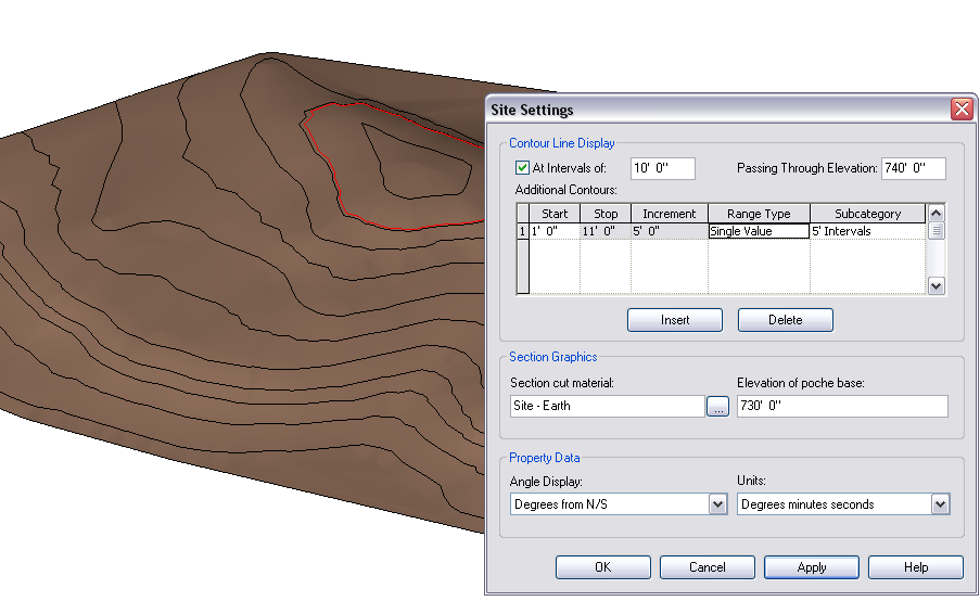
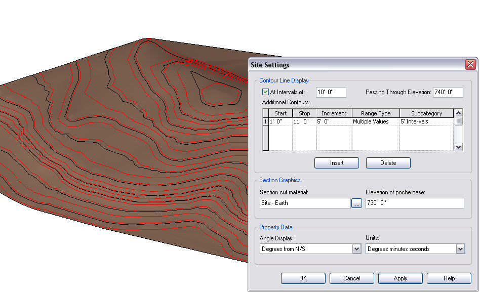
I assume you have already managed to create the topography?

If not you can create a topography directly from a 3D survey DWG file or you can draw the points in yourself at the correct elevation.


Your contours will never exactly match those of the survey drawing purely because on any surface there are numerous ways the contours can be drawn which still technically show the same surface.  In your Settings-->Site Settings is how you display what intervals your contours are displayed.


From the Help Menu:


Contour Line Display - Displays contour lines. If you clear the check box, custom contour lines still display in the drawing area.


At Intervals Of - Sets the interval between contour lines.


Passing Through Elevation - Contour intervals are based on this value. For example, if you set the contour interval at 10, contour lines display at -20, -10, 0, 10, 20. If the Passing Through Elevation value is set to 5, lines display at -25, -15, -5, 5, 15, 25.

Additional Contours

Start - Sets the elevation where additional contour lines begin.


Stop - Sets the elevation where additional contour lines no longer display.


Increment - Sets the interval for additional contour lines.


Range Type - Select Single Value to insert one additional contour line. Select Multiple Values to insert additional incremental contour lines.


Subcategory - Sets the type of contour lines to display. Select a value from the list. You can define custom contour line types using the Object Styles command, in the Topography category.


Section Graphics


Section cut material - Sets the material that displays in a section view.


Elevation of Poche Base - Controls the depth of the cross-section of earth (for example, –30 feet or –25 meters). This value controls the poche depth for all topography elements in your project.


Property Data


Angle Display - Specifies the display of angular values on property line tags. You can load property line tags from the Civil folder under the Annotations family folder.


Units - Specifies the units to use when displaying bearing values in the Property Lines table.


HTH.


Edited on: Wed, Jul 11, 2007 at 5:56:17 PM

-----------------------------------

Regards,

Chris.

Co-Founder | BIM Consultant | Software Designer  CryingB. Arch)

Xrev Revit API Addins | Revit Rants

This user is offline

View Website

Thu, Oct 4, 2007 at 3:29:07 PM | site map?

#3

jyodak


active

Joined: Wed, Jul 25, 2007
5 Posts
No Rating


I am having a strange problem with additional contour lines.  It seems that I can place individual additional contour lines and have them appear in the correct vertical location, but if I change from "Single Value" to "Multiple Value" I get additional contours at the interval I specify that pay no attention whatsoever to the Start and Stop fields.  This is in the latest version of RA 2008 (Revit Architecture 2008 - 20070810_1700).

I have attached two pics that show the settings dialogs for each case overlaid on the topography.  The idea is that I would like to see topo lines at 5' intervals on the lower portion of the site, where we will not be building much, and 2' intervals on the upper portion, but right now, I get both of them throughout the entire vertical range of the site.  The intervals I am trying to model are approximately what I will get from the survey engineer when he completes his work.  This topography was generated by eye in AutoCAD from USGS maps at 20' intervals, so it is not terribly accurate, merely informative.

Refer to the Start and Stop definitions from Mr Spot in this thread, which echo the extent of the help for these items anywhere in the Revit Help system.

 Jan S Yoder


Attached Images

28356_Countours_-_Single_Values.bmp28356_Countours_-_Multiple_Values.bmp

This user is offline


Thu, Oct 4, 2007 at 3:31:36 PM | site map?

#4

jyodak


active

Joined: Wed, Jul 25, 2007
5 Posts
No Rating


I am having a strange problem with additional contour lines.  It seems that I can place individual additional contour lines and have them appear in the correct vertical location, but if I change from "Single Value" to "Multiple Value" I get additional contours at the interval I specify that pay no attention whatsoever to the Start and Stop fields.  This is in the latest version of RA 2008 (Revit Architecture 2008 - 20070810_1700).

I have attached two pics that show the settings dialogs for each case overlaid on the topography.  The idea is that I would like to see topo lines at 5' intervals on the lower portion of the site, where we will not be building much, and 2' intervals on the upper portion, but right now, I get both of them throughout the entire vertical range of the site.  The intervals I am trying to model are approximately what I will get from the survey engineer when he completes his work.  This topography was generated by eye in AutoCAD from USGS maps at 20' intervals, so it is not terribly accurate, merely informative.

Refer to the Start and Stop definitions from Mr Spot in this thread, which echo the extent of the help for these items anywhere in the Revit Help system.

 Jan S Yoder


Attached Images

28357_Countours_-_Single_Values.bmp28357_Countours_-_Multiple_Values.bmp

This user is offline


Search this ThreadSearch this Thread | Page 1 of 1 |


Similar Threads

Thread/Thread Starter

Forum

Last Post

Replies

2d Location Map

Revit Building >> Technical Support

Tue, Nov 8, 2005 at 4:58:49 PM

5

The quickest way to show houses in a site map?

Revit Building >> Technical Support

Tue, Mar 29, 2011 at 8:22:22 AM

4

REVIT users map

Community >> Newbies

Wed, Sep 27, 2006 at 12:14:05 PM

1

help with orientation

Community >> Newbies

Mon, Sep 22, 2014 at 12:12:36 PM

0

Help with DWG import in Revit 2012

Community >> The Studio

Thu, Feb 23, 2012 at 3:40:00 PM

0

Site Stats

Members:

1990907

Objects:

22877

Forum Posts:

152181

Job Listings:

3

Sponsored Ads

Home | Forums | Downloads | Gallery | News & Articles | Resources | Jobs | Search | Advertise | About RevitCity.com | Link To Us | Site Map | Member List | Firm List | Contact Us

Copyright 2003-2010 Pierced Media LC, a design company. All Rights Reserved.

Page generation time: 0.3393

Login

User Name:

Password:

Remember Me  

Forgot Password?

Search Forums

Advanced Search

Search Forums

Advanced Search


Clear Highlights


Clear Highlights