Forums
|
Forums >> Revit Building >> Technical Support >> Topography Quality
|
|
|
active
Joined: Mon, Nov 20, 2006
5 Posts
No Rating |
The topography for Revit has been great for our firm until we realized that all of the time and effort we had put into adding points into our topography surface was somewhat all for not. After looking at a few project’s topography, we realize that the created surface from Revit actually doesn’t always follow our points. Has anyone noticed this situation and more importantly has anyone figured out how to configure Revit to follow all our points that we have painstakingly entered? I have read in previous posts that this is not one of Revit's strong points but does anyone know which points Revit chooses to use and how to know this? Or perhaps, what is the detail level the topography has when creating a surface? Any help would be greatly appreciated.
|
This user is offline |
View Website
|
 | |
|
|
site moderator|||

Joined: Mon, Jan 12, 2004
2889 Posts
 |
I've never known revit to not follow the points that you define to the topography. What I have noticed is Revit sometimes places the contour lines differently to how you'd like them to show. That said the contours revit shows are still correct based on your supplied points. You just have to put up with the contours being slightly differently represented. Until we can define a topography by drawings the actual contours in revit this will be an issue. But I don't believe it to be an accuracy issue.
-----------------------------------
Regards,
Chris.
Co-Founder | BIM Consultant | Software Designer  B. Arch) B. Arch)
Xrev Revit API Addins | Revit Rants |
This user is offline |
View Website
|
|
|
active
Joined: Mon, Nov 20, 2006
5 Posts
No Rating |
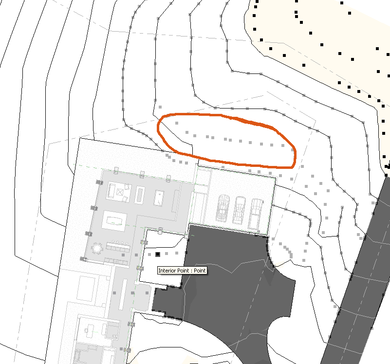
Thanks Mr. Spot for the response. What do you think about this screen shot? I understand that there might not be an answer to why Revit would not follow every point, but is there an ability to adjust the quality, or precision that Revit will have in regard to Topography? Similar to this screen shot, we will also have severe indentations within a topography elevation, such as if you were to trace the outline of your hand with the topography, and Revit will ignore or avoid the indentation, as if Revit would just connect your fingertips as a posed to following your finger down to your knuckle and back to the end of the next finger. Do you happen to know a way to trick Revit into following that indentation? We have tried to bombard the notch with points but that seems to have no effect on the sculpting of the topography that Revit creates. I know that this seems like a small inconvenience, however, when we create construction documents and the topography hits the building in different spots than we would like...could cause trouble. Once again thanks for the help.
|
This user is offline |
View Website
|
|
|
active
Joined: Tue, Nov 30, 2004
27 Posts
No Rating |
It is possible to use contours created in AutoCAD - 2D polylines in 3D space - then import the CAD drawing. Position the import wherever you want in the Revit model, then go to the Site panel, pick the Toposurface option, then the Import option. Pick the 'Import Instance' option, then pick on the imported CAD instance. Revit faithfully models the site based on the contours. This is anaccurate, easy and fast way to get data straight into Revit using the form we often get it from surveyors or civil consultants. We use the same method to transfer in their data for property lines, utilities, etc.
|
This user is offline |
View Website
|
|
|
site moderator|||
Joined: Mon, Jan 12, 2004
2889 Posts
|
" It is possible to use contours created in AutoCAD - 2D polylines in 3D space - then import the CAD drawing. Position the import wherever you want in the Revit model, then go to the Site panel, pick the Toposurface option, then the Import option. Pick the 'Import Instance' option, then pick on the imported CAD instance. Revit faithfully models the site based on the contours. This is anaccurate, easy and fast way to get data straight into Revit using the form we often get it from surveyors or civil consultants. We use the same method to transfer in their data for property lines, utilities, etc. " While this is a valid method, revits interpretation of the actual contours will still be different to the autocad definition. Mark, just ignore the contour lines showing... They mean nothing, they are simply an interpretation of revit as to how it thinks they should be represented and unfortunately there is no quality setting. That said if your points are right the topography surface will be correct in elevation. Even though you aren't getting that contour line showing that indent, you'll find the levels along that section will be correct as per your defined points. HTH.
-----------------------------------
Regards,
Chris.
Co-Founder | BIM Consultant | Software Designer B. Arch)
Xrev Revit API Addins | Revit Rants |
This user is offline |
View Website
|
|
|
active
Joined: Mon, Nov 20, 2006
5 Posts
No Rating |
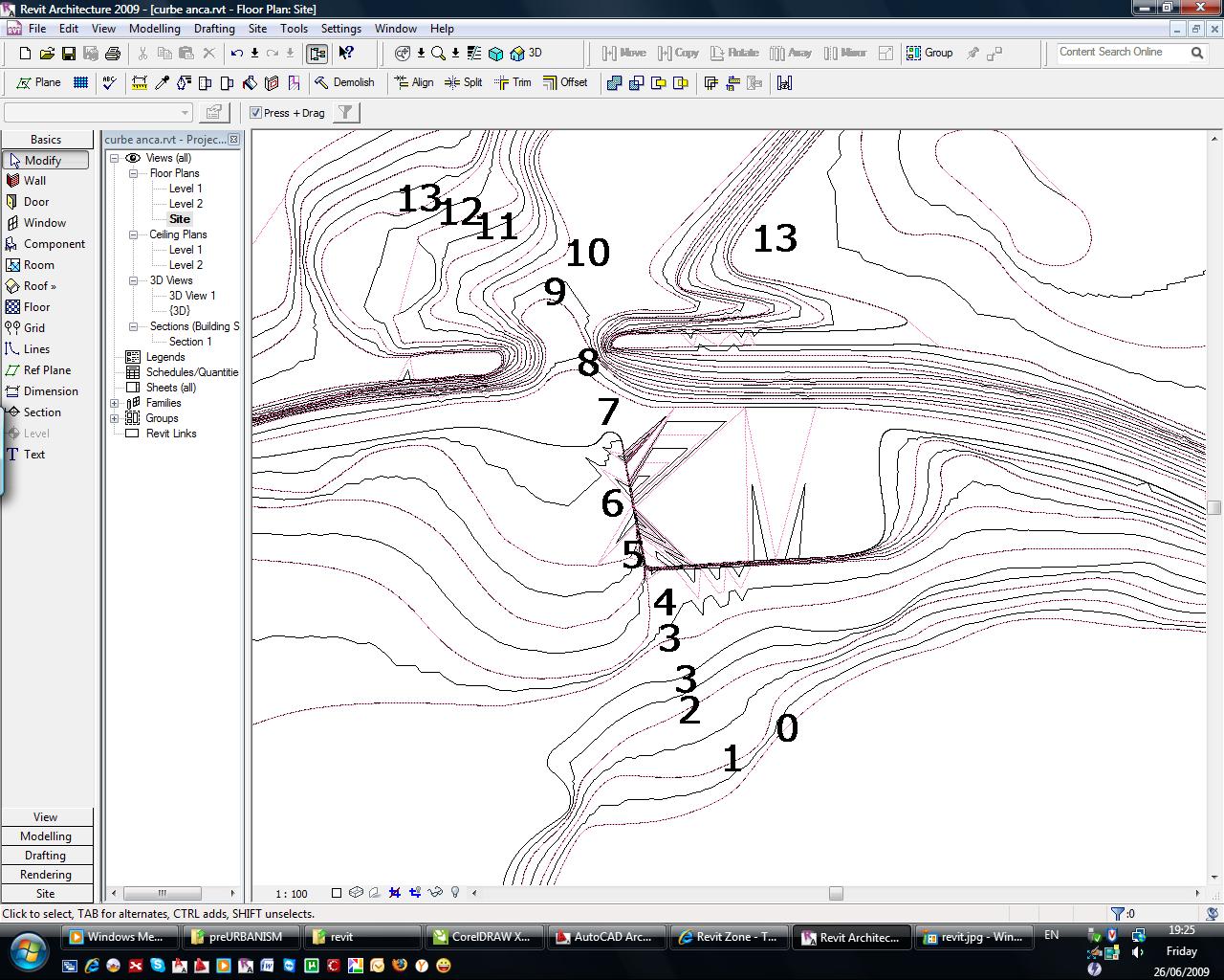
Mr. Spot Thanks again for the response. Try this picture out. Our biggest fear is that we are receiving topo from our surveyors, we are bringing those points into Revit, and then Revit is creating a topo skin that doesn't follow our entered points. I know that our points are in Revit correctly because when I try to edit the topography they are correct, as shown in the image provided. I can appreciate the accuracy in section and elevation, but our plan (and hopefully our 3D) needs to be correct too. Thanks again for the help, its tough to answer these questions.
|
This user is offline |
View Website
|
|
|
site moderator|||
Joined: Mon, Jan 12, 2004
2889 Posts
|
" Mr. Spot Thanks again for the response. Try this picture out. Our biggest fear is that we are receiving topo from our surveyors, we are bringing those points into Revit, and then Revit is creating a topo skin that doesn't follow our entered points. I know that our points are in Revit correctly because when I try to edit the topography they are correct, as shown in the image provided. I can appreciate the accuracy in section and elevation, but our plan (and hopefully our 3D) needs to be correct too. Thanks again for the help, its tough to answer these questions. " Like I said before the actual modelling of the topography will be correct in 3D. If the display of the contour lines in plan is a major issue, the only real solution is to turn them off and use the survey plan dwg as an overlay and display their contour lines instead. HTH.
-----------------------------------
Regards,
Chris.
Co-Founder | BIM Consultant | Software Designer B. Arch)
Xrev Revit API Addins | Revit Rants |
This user is offline |
View Website
|
|
|
active
Joined: Fri, Jun 26, 2009
10 Posts
No Rating |
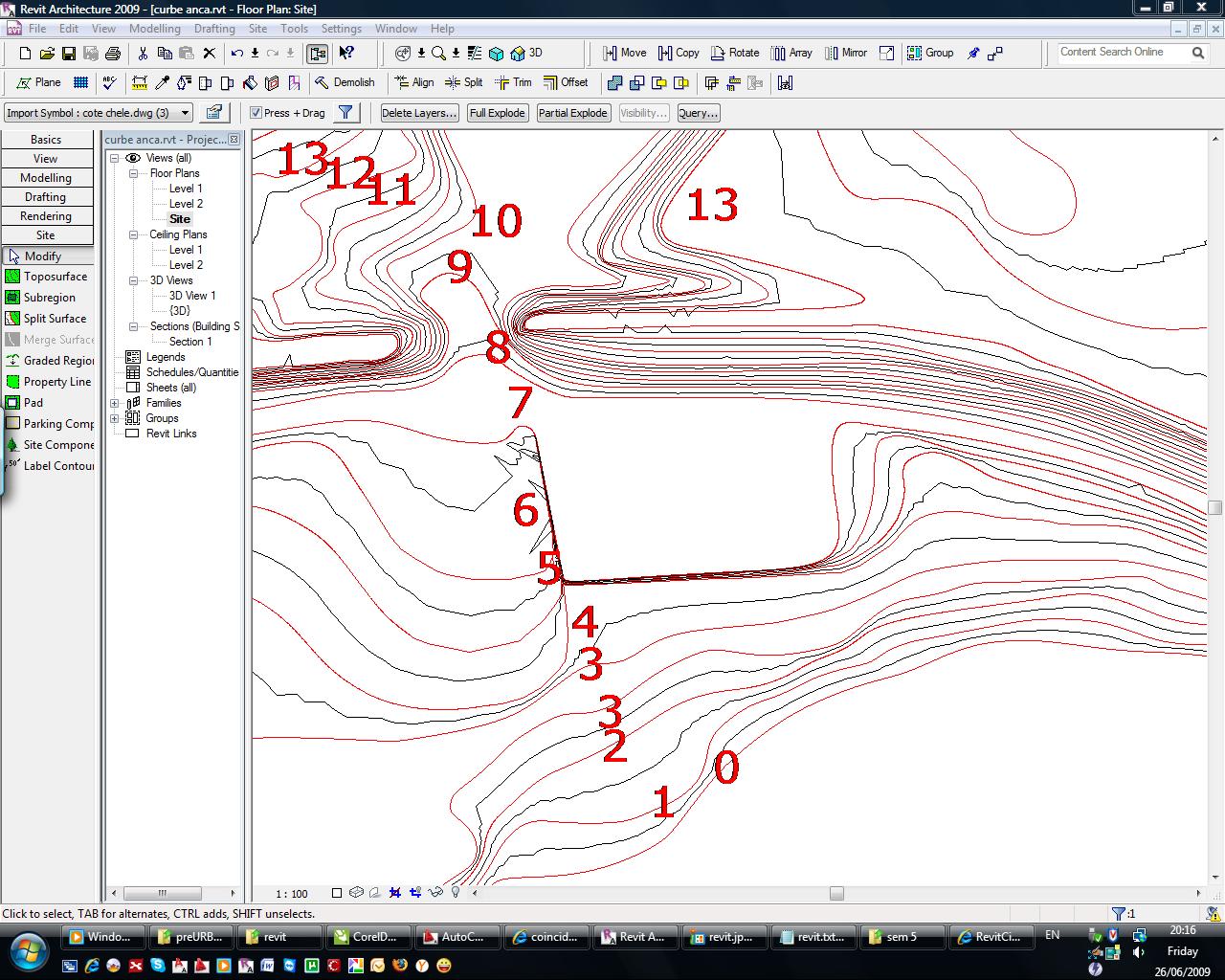
Can anyone tell me why this errors occurs in a topography? I atached the picture. This is a site generated with imported dwg splines...I am using Revit Architecture 2009. Pink lines are secondary lines. Thank you. Veronica.
-----------------------------------
Veronica |
This user is offline |
|
|
|
site moderator|||

Joined: Tue, May 22, 2007
5921 Posts
 |
Edit the Topo and increase the number of points in those zones...
-----------------------------------
I Hope and I Wish to LEARN more, and more, and more.... REVIT |
This user is offline |
|
|
|
site moderator|||
Joined: Tue, May 16, 2006
13079 Posts
 |
Maybe you should examine the points on the imported splines. I would look at the dwg in a 3d mode. I think you will find teh problems are in that file.
|
This user is offline |
|
| |
|
|
active
Joined: Fri, Jun 26, 2009
10 Posts
No Rating |
" Edit the Topo and increase the number of points in those zones... " Thanks a lot, it worked by increasing the number of points, but I still don't understand, why the Revit curves don't overlap the Autocad curves or points. The red lines are the dwg file. Is it possible to improve the quality of my toposurface somehow, I tried to use Simplify Surface tool but it did a slight difference. I am new to Revit so I might ask things that are already obvious to the others.  Veronica.
-----------------------------------
Veronica |
This user is offline |
|
|
|
site moderator|||
Joined: Tue, May 22, 2007
5921 Posts
|
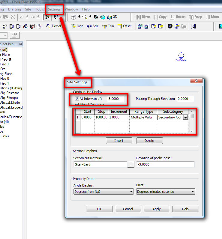
Go to Settings>Site settings then you can increse the value you want....
-----------------------------------
I Hope and I Wish to LEARN more, and more, and more.... REVIT |
This user is offline |
|
|
|
site moderator|||
Joined: Tue, May 16, 2006
13079 Posts
|
You said the cad drawing was splined. Splines in CAD follow a set of rules based on where the points are. Revit's topography lines too follow a set of rules based on where the points are but in this case, the points are probably few. Remember... topography lines are either just a "drafter's interpolation of surveyed points or a CAD interpolation. The points may be correct but between those points, two draftsmen could draw it differently. Mor points - more accuracy.
|
This user is offline |
|
|
|
active

Joined: Sat, Jul 5, 2008
30 Posts
No Rating |
Mark, You need to go to 'Settings'--> 'Site Settings' and then adjust distance between 2 contours down to 1' (or whatever the minimum distance you want to see on your drawing). Now your contour lines should follow the points you entered.
|
This user is offline |
|
|
|
active
Joined: Fri, Jun 26, 2009
10 Posts
No Rating |
Thanks for your responses. I've managed it!
-----------------------------------
Veronica |
This user is offline |
|
|
|
Similar Threads |
|
walkthrough file in bad quality |
Revit Building >> Technical Support
|
Sun, Jul 11, 2010 at 1:27:52 PM
|
4
|
|
TOPOGRAPHY SPLIT PROBLEM |
Revit Structure >> Technical Support
|
Mon, Sep 22, 2008 at 2:51:42 PM
|
4
|
|
Topography |
Revit Building >> Technical Support
|
Wed, Oct 19, 2016 at 6:19:21 AM
|
2
|
|
Topography dissapearing |
Revit Building >> Technical Support
|
Wed, Nov 7, 2012 at 2:46:15 PM
|
2
|
|
Font Quality |
Revit Building >> Technical Support
|
Wed, May 11, 2022 at 10:38:16 AM
|
1
|
|
|
Site Stats
Members: | 2161655 | Objects: | 23325 | Forum Posts: | 152479 | Job Listings: | 3 |
|