|
|
|
Home | Forums |
Downloads | Gallery |
News & Articles | Resources |
Jobs | FAQ |
| Join |
Welcome !
|
8 Users Online (6 Members):
Show Users Online
- Most ever was 626 - Mon, Jan 12, 2015 at 2:00:17 PM |
Forums
|
Forums >> Revit Building >> Technical Support >> Elevation of Topo points
|
|
|
active
Joined: Sun, Mar 11, 2012
25 Posts
 |
Dear experts;
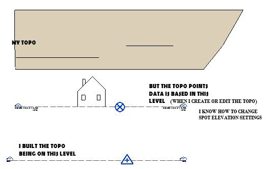
I am building a topo by placing points manually (Rvt 17).
Whatever layer I am on while starting the topo, the data of the points is shown as "Absolute Elevation" but always calculates the height from the Project Base Point.
If i pull the Topo down, the points' data changes and is not real anymore.
If i move PBP to the sea level, the whole project will go down and the Topo will be still above the building.
The upper level base is to PBP, the lower levelbase is Survey. Both are Zero.
What am I doing wrong?
Thanks.
|
This user is offline |
|
 | |
|
|
site moderator|||
Joined: Tue, May 16, 2006
13079 Posts
|
Revit's topo by point has never been explained well in the HELP so I will try to give you some clarity.
- The topo created by point is NEVER related to the Project Base Point or Project Survey Point. It seems to be related to a hard coded, Default First Floor Level 0. (This seems to be real world, survey elevation - 0)
- Initial Project and Survey points are defaulted to elevation 0 as well.
- Any absolute point entries will be relative to that Level 0.
- Any site created can be moved up/down in section/elevation and the points will reflect that move from the hard code level 0.
- Changing the elevation of the floor levels will have no affect on the site, it will only affect the building model.
- Watch this video to learn how to move the project or survey points. http://www.youtube.com/watch?v=BigvY4LT-RI
|
This user is offline |
|
|
|
active
Joined: Sun, Mar 11, 2012
25 Posts
|
Thank you for the quick reply and very good explanation.
I've seen that video and understand the survey point and PBP essence.
You mean that the topo points have elevations from the Project Origin (which I won't be able to see)?
Not from the sea level?
Taking into account the project location, it looks like from the sea level.
The survey point on my drawing is on the same level on which i bild my topo. Survey elevation is Zero. The level (topo's base) is also Zero.
The PBP is on the Ground floor, and the topo is generated from the Ground floor.
As I understand from youe explanation, it is impossible to change.
The only option I have is to build the topo somewhere above everything and pull down.
How then I could edit it in the future? The point elevations will be wrong if i pull the topo down.
Thanks.
|
This user is offline |
|
|
|
site moderator|||
Joined: Tue, May 16, 2006
13079 Posts
|
I think you are understanding correctly. Here are some additional thoughts.
- When you move your topo to the correct location relative to the real world, the spot points will always be correct using spot elevation (survey) tags.
- I almost always built my topo in a seperate file and linked it in. Most of us don't think of this topo in real elevation numbers like elevation 968.75, we work from a site point + and - ... typically calling that 100. Working in a seperate file allows us to maintain that thought process. Here the topo will always be the original numbers from that 100. But when linked into the project, we move it up/down to where it will correctly be.
|
This user is offline |
|
|
|
active
Joined: Sun, Mar 11, 2012
25 Posts
|
Thank you.
I just could not imagine that so simple a problem - a possibility to set points normally, from the survey - could not be solved for so many years.
Thanks again. You really helped me.
All the best!
|
This user is offline |
|
|
|
active
Joined: Sun, Mar 11, 2012
25 Posts
|
Hi WWHub,
Your entry is the best of all I ‘ve found on the topic online.
I think it would be extremely helpful for many users if you (when you have time) expanded your points 1-6, and enrich them with examples. Images could make the explanation remarkable.
|
This user is offline |
|
|
|
Similar Threads |
|
Selecting Topographic Points based on Elevation |
Revit Building >> Technical Support
|
Tue, Aug 7, 2012 at 3:16:32 PM
|
5
|
|
Abolute Elevation and Topo Points - Revit Architecture 2009 |
Revit Building >> Technical Support
|
Wed, Feb 10, 2010 at 12:51:32 PM
|
4
|
|
Topo surface points change from relative to absolute elevations [ 1 2 ] |
Revit Building >> Technical Support
|
Thu, Apr 7, 2016 at 9:33:19 AM
|
15
|
|
Toposurface glitch? |
Revit Building >> Technical Support
|
Thu, Jul 18, 2013 at 9:34:40 AM
|
6
|
|
Topo |
Revit Building >> Technical Support
|
Sat, Sep 27, 2008 at 12:05:04 PM
|
1
|
|
|
Site Stats
Members: | 2161655 | Objects: | 23325 | Forum Posts: | 152479 | Job Listings: | 3 |
|