Forums
|
Forums >> Revit Building >> Technical Support >> Toposurface Elevation Base Point
|
|
|
active
Joined: Wed, Mar 7, 2012
0 Posts
No Rating |
Hello. I have had a lot of help from this forum, although never asked a question directly. After a bit of searching, I have not found my answer, so I am hoping someone can assist.
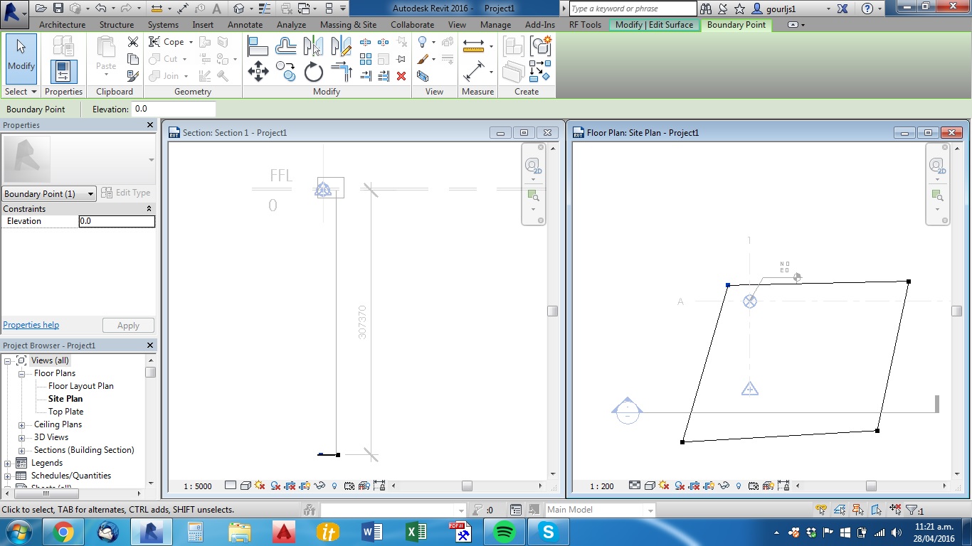
I am setting up a project template, but can not set my Toposurface elevation correctly. Project base point set to 0, 0, 0, Survey point set to 0, 0, 0 as a starting point.
I have my two standard levels in at 0 (FFL) and 2760 (Top Plate), and these show up fine in relation to the project base point, which they are set to reference from.
When I place toposurface boundary points with an elevation of 0 to create a flat surface, I would expect the plane of this surface to be aligned with my FFL at 0. If I chose to raise FFL, I could change the level elevation, but toposurface should stay at 0.
What I am getting is that my toposurface points with an elevation of 0 are creating a surface which is 307,370mm below FFL (about 1000 feet).
I can't seem to figure out what the boundary points are referencing from, and can't change this.
Maybe something simple I don't know about, please enlighten me.
Thanks,
Jimmy
|
This user is offline |
|
 | |
|
|
active

Joined: Mon, Nov 19, 2007
93 Posts
 |
If you go to Project Base Point, unclip it, right click on Project Base Point and select Move to Startup Location in the popup window does the Project Base Point move?
-----------------------------------
__________I'm the guy they come to when they didn't follow my recommended workflows.__________ |
This user is offline |
|
|
|
site moderator|||
Joined: Tue, May 16, 2006
13079 Posts
|
The topography creation process needs to be clarified by autodesk because it is really confusing.
There are several things involved here that you need to research and learn if you want to use Revit for this work. First, you need a thorough understanding of Project Base Point / Survey Point. This is the best tutorial I have found.
http://www.youtube.com/watch?v=BigvY4LT-RI
You also need to understand the use of Relocate Project. Obviously, you can move a level up/down in elevation to the correct level but that does not change all of the associated functions in Revit. Project North and True North are also important to learn and understand.
Now - about your problem in this instance and until you learn the above, you can move the entire site in elevation/sections, just like you can levels. Just pick it and move it up/down. If say your base level is 0 but survey 307,370 - if you move the topography to match your level, Point Elavations (survey) will read correctly.
When you create topography by entering points, the points used are default referenced from a built in 0 elevation. So editing the topography initially is now all relative to that 0. Moving the floor level will not move this reference. If you have done that and you now simply move the site as I suggested above, when you now edit the topography, points that were 0 will now be 307,370 ...etc.
However, if you have not moved your project base point and you have built your topography in relation to that initial 0 level, you can move your project base point to the correct elevation and everything will move accordingly. When editing the topo, points will still be relative to 0 but the 0 is your new location - not survey.
Edited on: Thu, Apr 28, 2016 at 12:49:18 PM
|
This user is offline |
|
|
|
active
Joined: Wed, Mar 7, 2012
0 Posts
No Rating |
Thanks Beaucoopnice and WWWHub.
Project base point was helpful, I was unaware of that function. Thanks.
WWWHub, I am familiar with all of those functions. Project/true north are a great function that I have spent a lot of time explaining to colleagues who insist on rotating viewports. Seems to be something a lot of people struggle with.
I have watched that tutorial in the past. Didn't really help with my problem in this instance as it does not address the built in, invisible 'origin'. What has confused me is the fact that all model items are relevant to 'project base' or 'survey' points, apart from Topography, which is relevant to this Revit native origin point.
Seems to me it would be better to have an option where Topography is either relative to survey point, or to project base point, but perhaps there is something I am missing.
WWWHub, I understand that I could have moved my topo to match my level, and spot coordinates would have worked, but if I were to change the topo points, or add new topo points for a graded region etc, I would have had to either:
a) move my topo down 307,370 - change topo points - move topo up 307,370 , or;
b)Add 307,370 to all my desired points. This means when my site is approx. 320m above MSL, and I want a point in my graded region at 319,850, I have to select 627,220 for my elevation of the topo point. A real hassle.
To solve my problem I have done the following, which may not be best practice but has worked for me, and may help others:
- Unclip Project Base Point and move to startup location
- Unclip Survey Point and move to project base point.
- Both Points now 0,0,0, Move levels to 0 and 2760, topo still -307370
- Select in elevation project base, survey point and levels. Move down to match Topo. (I understand this is not 100% accurate, as you can not snap to the topo, but by zooming I managed to get to 307367.4, which is more than accurate enough for an earthworks contractor to work off!)
- Base, survey points, level FFL and - most importantly - topo boundary points, are now all at 0 elevation.
For my scenario, I will now clip survey point to stay at mean sea level. Move unclipped Project Base Point and Levels up to 320000 (a good starting point for a template in my area). Can then have my topo points as true elevation when inputting.
As this is a template, it is easy enough as there is no model to be working around. Although it shouldn't cause too many issues if everything is related to your levels, as I like to do.
I guess my problem arose from the Project Base and Survey points being shifted from Revits NATIVE ORIGIN (for lack of the real term) prior to me modifying the template, and trying to fix this issue. I could have started again modifying a revit template, but would have lost my sheet sets, imported data, preferences etc. Transfer project standards could fix some, but not all of these, and I would have to purge out all the useless families which I have spent time purging previously.
Hopefully this will be of help for someone, as I know I'm not the first with this issue. Thanks for your help Beaucoopnice and WWWHub.
|
This user is offline |
|
|
|
active
Joined: Wed, Mar 7, 2012
0 Posts
No Rating |
PS. All these years I'd been thinking the Revit workspace was one big white lonely void. Now I find that I am not the ruler of my Revit universe (via project base/survey points) but there is a center to my universe. I guess Autodesk could never let that be the case.
Maybe there is something else out there, and we aren't alone in this vast white land.
The mind boggles.
|
This user is offline |
|
|
|
Similar Threads |
|
Toposurface is drawn at the wrong elevation relative to levels |
Revit Building >> Technical Support
|
Fri, Aug 4, 2017 at 12:09:48 PM
|
3
|
|
Topography Elevation from Project Base and Survey Point is Incorrect |
Revit Building >> Technical Support
|
Thu, Jan 29, 2015 at 10:32:24 PM
|
9
|
|
Display both Project Base Point and Survey Point on Elevation Datum. |
Revit Building >> Technical Support
|
Fri, Aug 29, 2014 at 5:57:41 PM
|
2
|
|
Toposurface Elevation |
Revit Building >> Technical Support
|
Mon, Mar 26, 2007 at 8:03:00 AM
|
2
|
|
Spot Elevation/ Level with both "project base point" and "survey point" 2017 |
Revit Building >> Technical Support
|
Mon, Nov 27, 2017 at 5:33:42 PM
|
1
|
|
|
Site Stats
Members: | 2161655 | Objects: | 23325 | Forum Posts: | 152479 | Job Listings: | 3 |
|