|
Forums >> Revit Building >> Technical Support >> Toposurfaces and Project Elevations
|
|
|
active
Joined: Mon, Mar 14, 2011
21 Posts
No Rating |
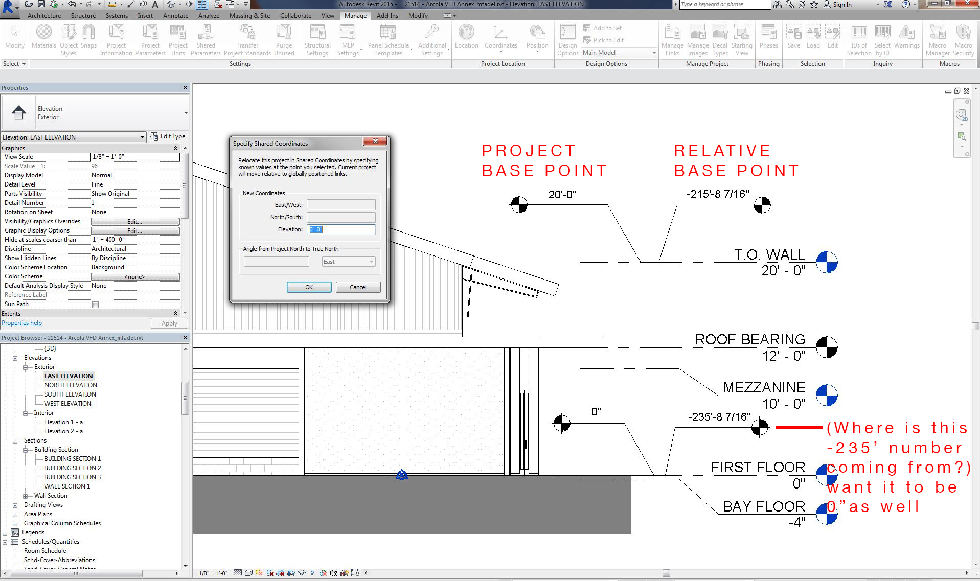
I am trying to understand why my project seems to be listed at approximately -200' below 0, when my project and survey points have both been set to 0'-0"? The question came when I began creating a toposurface with absolute elevation at 0'-0" and I found it floating a couple-hundred feet above my building (in a 3D view). I did not find some errant level way up in space either that would be allowing the spot elevation (with relative base point set to "current level") to be drawing information from elsewhere. Any suggestion of where to adjust this -200ish elevation so that the first floor level is truly at 0'-0" would be appreciated. Thank you!
|
This user is offline |
|
 |
|
|
|
site moderator|||
Joined: Tue, May 16, 2006
13079 Posts
 |
There are a lot of things possibly going on here. Understanding all of this in Revit takes awhile.
NOTE: Your spot elevation is set to relative to the current level. We don't know what you have as the current elevation ... A building Elevation view has no associated level. So change that from relative to project base point.
If you can, always try to create your topo from an imported survey or points file. When you create a topo by placing points, the default 0 is relative to your base level. Not really your survey or your project base point. So point elevations entered here are almost meaningless. Especially if you later use the relocate project.
|
This user is offline |
|
|
|
active
Joined: Mon, Mar 14, 2011
21 Posts
No Rating |
So I guess the real question is, how do I establish the current level? I know I can change the spot elevation to read the appropriate setting (changing to project/survey base point), but this doesn't solve my real issue which is to get everything in this project set to a 0'-0" elevation. I recognize there are many pieces to this puzzle, but it seems like a simple request. And unfortunately, I do not have a civil drawing I can use right now for creating topo and am forced to use the toposurface tool. Apparently other projects in the office have had to deal with this which means it's something that is residing in our office template so I'd like to resolve it rather than just work around it in my case.
|
This user is offline |
|
|
|
site moderator|||
Joined: Tue, May 16, 2006
13079 Posts
|
Look at the type settings for your spot elevation. It is currently set to relative. If your project base point is set to 0 then setting the spot elevation tag to project should solve your problem. We have all three tag types in our projects so you can use the correct one for your needs.
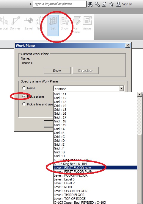
Work planes can be set in any view from the architecture tab / set "ref plane".
|
This user is offline |
|
|
|
active
Joined: Mon, Mar 14, 2011
21 Posts
No Rating |
I suppose I'm not making myself explicitly clear. I acknowledged that I can change the tag to get the correct reading on my elevations. What I want to fix is some errant elevation of ~ -200' that is somewhere in the project. This will allow me to create a topo surface with points (a simple exercise) without having to do a lot of unneccesary calculations whenever I want to adjust the topo around my building. To put simply, where is the -235' coming from and how to I change it to 0"?
|
This user is offline |
|
|
|
site moderator|||
Joined: Tue, May 16, 2006
13079 Posts
|
Let me say this again.... YOU ARE THE ONE THAT SET'S THE WORK PLANE FOR AN ELEVATION VIEW! I don't, Revit doesn't. So do that. Set the work plane to your ground floor in that elevation view. Now your relative spot elevation will be correct.
|
This user is offline |
|
|
|
active
Joined: Mon, Mar 14, 2011
21 Posts
No Rating |
Being close to broke on this issue, I gave it a try. In fact, I had two other people in the office try as well (one of whom is our BIM manager) and neither of them had any luck, much less felt like this would be an appropriate solution. No dice.
Is Mr Spot anywhere to be found? A moderator with some different insights and a professional tone might be the better avenue.
|
This user is offline |
|
|
|
site moderator|||
Joined: Tue, May 16, 2006
13079 Posts
|
I believe you are really asking two questions and don't know it. Let me ask you this.... When did you delete the original first floor level and create a new one?
|
This user is offline |
|
|
|
active

Joined: Sat, Sep 4, 2010
173 Posts
|
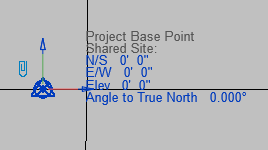
Can you verify from a Site Plan view what your Project Base Point and survey Point display when you select them? I would agree that it is difficult to understand what your spot elevations are in reference to in those views. Is it just the topo or are there other object there that may be showing up in that view?
|
This user is offline |
|
|
|
Similar Threads |
|
Merging Toposurfaces |
Revit Building >> Technical Support
|
Tue, Apr 21, 2015 at 8:07:53 AM
|
4
|
|
Can you tell a building pad to cut multiple toposurfaces? Revit 2014 |
Revit Building >> Technical Support
|
Tue, Aug 12, 2014 at 2:45:16 AM
|
3
|
|
Default Elevations missing in project |
Revit Building >> Technical Support
|
Fri, Apr 5, 2013 at 7:21:37 AM
|
3
|
|
elevations missing |
Revit Building >> Technical Support
|
Tue, Jan 24, 2006 at 7:57:13 AM
|
1
|
|
Toposurface point reporting |
General Discussion >> Wishlist
|
Fri, Mar 15, 2013 at 11:16:07 AM
|
0
|
|