Forums
|
Forums >> Revit Building >> Technical Support >> Topography Elevation from Project Base and Survey Point is Incorrect
|
|
|
active
Joined: Wed, Oct 16, 2013
8 Posts
No Rating |
This has been driving me nuts, I'm not sure what's wrong...but it must be something with the way my file is setup.
A quick description:
I'm in Level 1 of my model with the site/location/coordinites set to 0', the Survey Point and Base Point (see attached) are also set to 0' at Level 1. When I model a topo, no matter what elevation points I use (in this case, as a test I just put all the points at 0'), the topo is coming in 23'-9" too high. I've tried to view the spot elevation from Base Point and Survey Point, same problem. If I use the "Relative" option, it gives me the correct elevation, although when looking at the model, it's still high.
This must be a problem with my file, but I'm not sure how to fix it. I opened up a blank, new file and modeled a topo with no problems.
|
This user is offline |
|
 | |
|
|
site moderator|||
Joined: Tue, May 16, 2006
13079 Posts
 |
Watch this video. http://www.youtube.com/watch?v=BigvY4LT-RI
|
This user is offline |
|
|
|
active
Joined: Wed, Oct 16, 2013
8 Posts
No Rating |
Thanks for the video, but I'm still having the same issue.
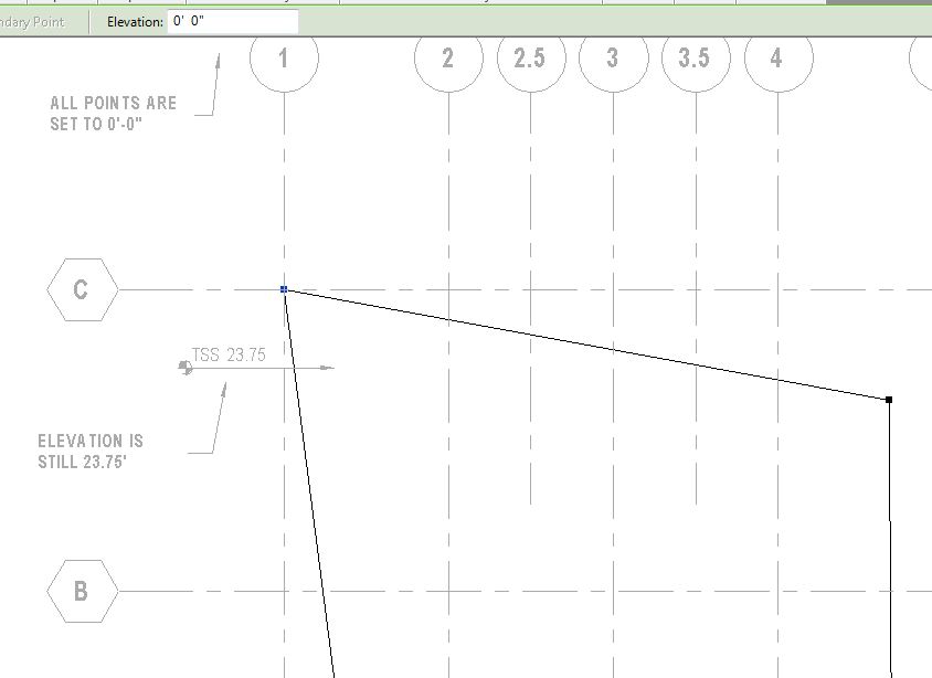
My Project Base and Survey are at the same exact location, so I don't think there is an error there (see the images in the original post). The top is physically being modeled incorrectly based on the numbers I am entering. If I want to model a floor, and put in a 10' elevation, it is perfectly fine, and shows up at 10'. For some reason this is only happing with topo, no matter what elevations I put for the control points, it is being modeled at 23'-9" too high, I have no clue where that number is coming from.
|
This user is offline |
|
|
|
site moderator|||
Joined: Tue, May 16, 2006
13079 Posts
|
This is a process error, I'm sure. Pay attention to what the video shows..... especially what is referenced. Experiment like the video shows with multiple tag types and label them so you see what happens.
Did you possibly move this building?
|
This user is offline |
|
|
|
active
Joined: Wed, Oct 16, 2013
8 Posts
No Rating |
I've really been working on this simple problem for hours now, I even have others in the office doing the same. I agree with everything the video says (and I've done this so many times)....which is why I think something could be wrong with my file.
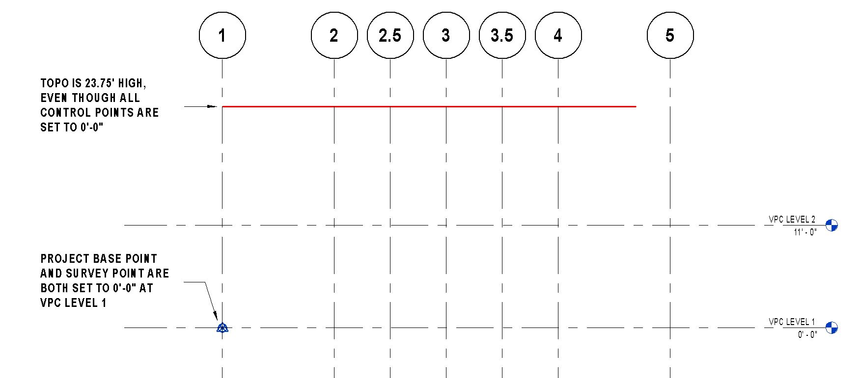
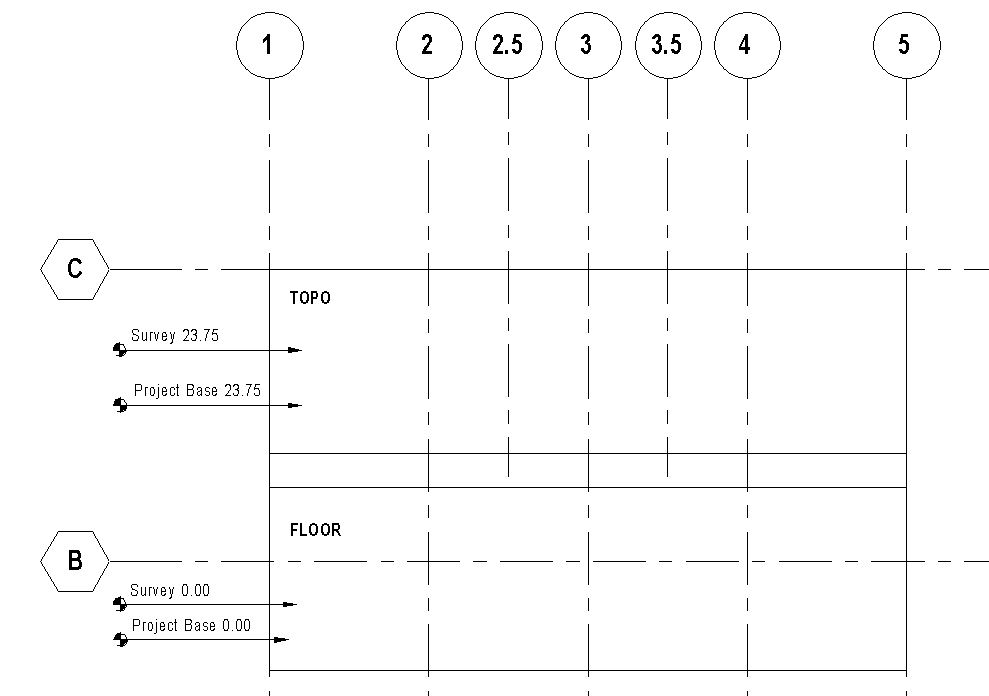
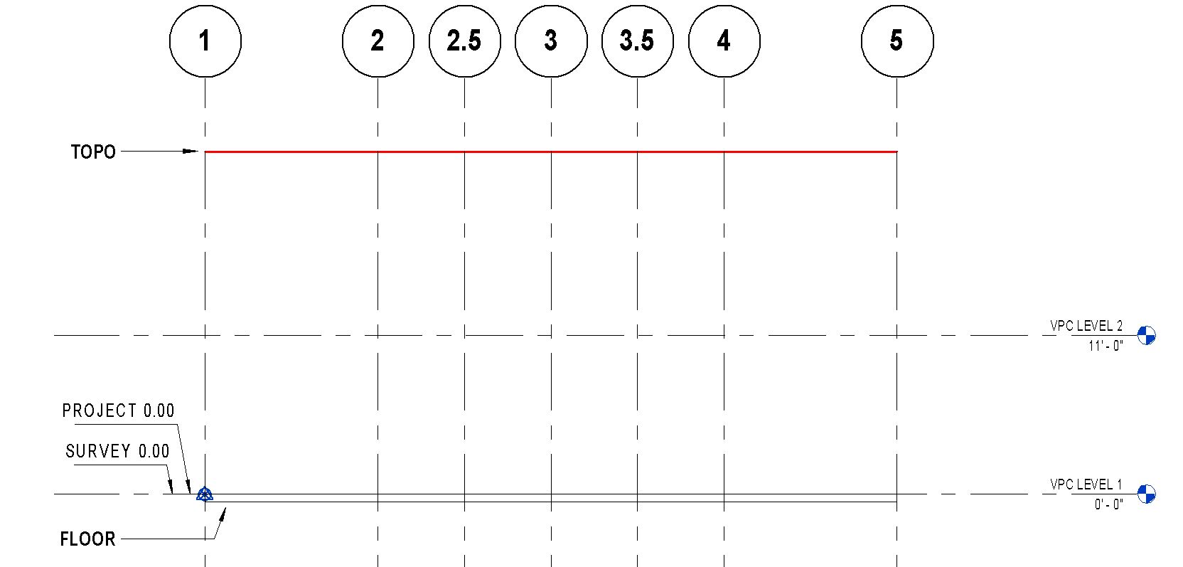
If you look at the attached images, I've modelled a Topo and a Floor, both with an elevation of 0'-0". The floor is correct, the topo is still 23'-9" higher than it shoudl be. You can also see in the images that the survey and project base are at the same elevation.
There is no building to move in this file, it is a template I created for future projects in our office so there is actually nothing modeled. One of our users came across this problem, so now I am testing it and having the same issue. I've tried creating a new file from scratch, and everything works perfectly fine.
So frustrating!!!
|
This user is offline |
|
|
|
site moderator|||
Joined: Tue, May 16, 2006
13079 Posts
|
I don't understand.
You write: "...There is no building to move in this file, it is a template I created for future projects in our office so there is actually nothing modeled...."
Then you write: ".... I've tried creating a new file from scratch, and everything works perfectly fine...."
There is a contraditiction there unless you mean something else. If you mean from scratch is not using your template, then maybe something is corrupted in your template. Make a new one. You can "transfer project standards" (BE SELECTIVE!) and see how your new template works.
|
This user is offline |
|
|
|
active
Joined: Wed, Oct 16, 2013
8 Posts
No Rating |
We have been using this template, and this is the error our users have found when building models.
As a test, I tried creating a new project from scratch with the template. The only element I modeled in this file were a topo and a floor to see check for the problem....and yes, it occurs. So there is no building to movie means, I'm working in the template file with a blank canvas - no model to move besides the test components I've created.
|
This user is offline |
|
|
|
active
Joined: Wed, Oct 16, 2013
8 Posts
No Rating |
Found the solution from our Revit distributers help desk:
If I right click on the Project Base Point and choose “Move to Start Up Location” then the coordinates of the PBP reads as:
N/S -5’ 3 213/256”
E/W -169’ 1 7/64”
Elev 23’ 9”
So, that explains where the 23’ 9” is coming from. The solution now would be to relocate the survey point to that same origin / start up location and get both the project & survey points to read as 0,0,0. For future reference, keeping the project base point at the start up location is ideal. (Then you can use “origin to origin” when linking or importing files)
|
This user is offline |
|
|
|
site moderator|||
Joined: Tue, May 16, 2006
13079 Posts
|
I suggested you DON'T USE YOUR TEMPLATE! ... to see if there is a corruption there.
Also, we have been asking posters to always state their Revit issue and current update. We could be wasting a lot of time here because you may not have the latest update installed. Revit is not always perfect with the initial release. We never start using a new release until after update 1 is issued. 2014 has update 1.
|
This user is offline |
|
|
|
active
Joined: Thu, Dec 13, 2012
0 Posts
No Rating |
Project start point, AKA "The Origin." I confess I find it sort of ghostly; it's invisible, but exercises it's power in subtle and maddening ways.
Kunalp states below:
If I right click on the Project Base Point and choose “Move to Start Up Location” then the coordinates of the PBP reads as: N/S -5’ 3 213/256”, E/W -169’ 1 7/64", Elev 23’ 9”
He leaves out only one thing: you must unclip the Project Base Point in order to do this.
I have only found two types of Revit objects that relate only to the Project Start Point, and can't be toggled to either Project Base Point or Survey Point. Those are elevations of toposurface points, and elevations of eye and target in 3D views.
Those of us raised in AutoCAD can surely relate to the desire to locate our drawing logically with respect to the 0,0,0 point. I tended to be suspicious of any drawing that was not corefully located. As it turns out, this is good practice in Revit as well. The difference seems to be that the Project Startup Point, unlike the Project Base Point or the Survey Point, has no handy icon that can be toggled to be visible. It's hard to find without inserting something from outside the file.
A drawback of keeping the Survey Point at the same location as the Project Base Point is that you lose some of the benefits of the concept of a Survey Point. By destinguishing them, while being very careful with your clipping and unclipping, you can differentiate true north from project north, and other good things.
|
This user is offline |
|
|
|
Similar Threads |
|
Level that reads both Project Base Point and Project Survey Point |
Revit Building >> Technical Support
|
Tue, Jun 9, 2015 at 9:39:37 AM
|
2
|
|
Display both Project Base Point and Survey Point on Elevation Datum. |
Revit Building >> Technical Support
|
Fri, Aug 29, 2014 at 5:57:41 PM
|
2
|
|
Spot Elevation/ Level with both "project base point" and "survey point" 2017 |
Revit Building >> Technical Support
|
Mon, Nov 27, 2017 at 5:33:42 PM
|
1
|
|
Survey Point and UTM coordinates |
Revit Building >> Technical Support
|
Mon, Jun 20, 2016 at 3:50:02 PM
|
1
|
|
Project base point/ Survey Point |
Revit Building >> Technical Support
|
Tue, Nov 13, 2012 at 3:35:36 PM
|
10
|
|
|
Site Stats
Members: | 2161655 | Objects: | 23325 | Forum Posts: | 152479 | Job Listings: | 3 |
|