|
|
|
Home | Forums |
Downloads | Gallery |
News & Articles | Resources |
Jobs | FAQ |
| Join |
Welcome !
|
17 Users Online (15 Members):
Show Users Online
- Most ever was 626 - Mon, Jan 12, 2015 at 2:00:17 PM |
Forums
|
Forums >> General Discussion >> Revit Project Management >> Modelling terrain Revit imported from AutoCad
|
|
|
active
Joined: Thu, Oct 20, 2011
1 Posts
No Rating |
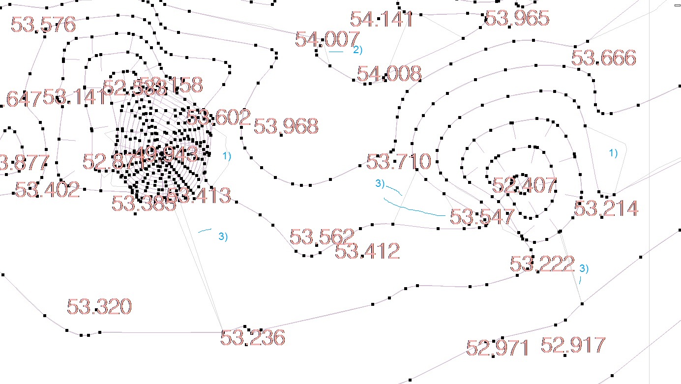
I'm building a terrain imported from AutoCAD and Revit. I followed all the right steps with regard to the import dwg file to rvt file and pursue the auto play, adding then the extra points to level curves.
When i finish editing and still in the sketch, the land in Revit is, surely, designed with accuracy in relation to AutoCad: all points associated with the contour and outside the contour, with its altimeter according to source file.
However, as the final result was also denote differences in AutoCad for the following:
1) - Although the points are designing the exact contours of the final reproduction of the land does not match the AutoCad because Revit is not doing the proper contour of the curve;
2) - Although there are extra points marking the contours, Revit does not seem to play well coincident with AutoCad, so occasionally it involves / associate the point on the contour nearest;
3) - Revit appears to still make a strange marriage between points of equal altimeter but located in different contours or not - this creates a strange representation of the topography.
Can anyone find solutions to resolve the topography more accurately compared to AutoCad, what i mean is, in relation to the original survey?
I appreciate the comments. Thank you.
|
This user is offline |
|
 | |
|
|
site moderator|||
Joined: Tue, May 16, 2006
13079 Posts
 |
If you ever hand drafted contour lines from a survey, you would know that contour lines are arbitrary. Given the same information, two drafters might draw them differently. It is unimportant that the CAD lines and yours don't match. What is important is that your spot elevations are correct.
You need to decide if you will print with Revit contours or CAD. Just do one or the other.
|
This user is offline |
|
|
|
active

Joined: Fri, Sep 22, 2006
759 Posts
 |
I have hand drafted numerous contour maps, and there is sort of an art to it, that is to catch grade breaks correctly, and minutia. You can do a contour map in Revit with far less point than you imagine, and you can adjust the contours around to look more correct, if you don't like the result of the Revit conversion, by just adding a point here or there you can make the contours shift, don't try to set points on the contour line rather, set elevation points just above and or below the contour line this way you can influence the appearance of the contour line on your map. Generally, I don't mess around with this much accept on roadway areas which seem to be a little trickier.
|
This user is offline |
|
|
|
Similar Threads |
|
revit terrain and roads |
General Discussion >> Revit Project Management
|
Wed, Jul 25, 2012 at 2:19:58 AM
|
4
|
|
SketchUp to Revit Terrain Snapshot |
Revit Building >> Tips & Tricks
|
Tue, Sep 17, 2013 at 10:36:49 AM
|
0
|
|
3D Acad model to toposurface |
Revit Building >> Technical Support
|
Fri, Jun 15, 2012 at 2:38:12 AM
|
0
|
|
autocad visibility in revit 2008 |
Revit Building >> Technical Support
|
Wed, Jun 20, 2007 at 5:43:06 PM
|
3
|
|
Changes to AutoCAD layers when imported to Revit |
Revit Building >> Technical Support
|
Wed, Oct 29, 2008 at 10:35:39 AM
|
1
|
|
|
Site Stats
Members: | 2161655 | Objects: | 23325 | Forum Posts: | 152479 | Job Listings: | 3 |
|