Forums
|
Forums >> Revit Building >> Technical Support >> Pad, topo, underground bldg - has a true resolution been found?
|
|
|
active
Joined: Tue, Sep 16, 2008
14 Posts
 |
I know this question has been asked in one form or another many times in the forums, and often each question is referred back to a search thread for "tunnel" or "underground", but as much as I have searched all through these threads, I have never found a definite answer (or a sure response of "you just can't do it"). So fingers crossed...I have a project with many below grade floor levels and only a small access building above grade to enter the lower structure. The bottom most levels are a larger footprint than the higher below-grade levels, and the grade level structure is the smallest. So there is substantial depth of ground cover over most of the building. If I use the Pad method, it cuts the lowest footprint outline all the way to the surface, but leaves a void in the space between the outline of the pad and the exterior of the higher levels. Plus, the entire structure is exposed at grade. In Revit 2011... do we know of a method to contour the earth around the model's exterior in both plan view axis and also contour the model in a side/elevation/section cut axis? Changing visibility graphics to hide the section cut earth hatch is not acceptable since it still ruins the depth of the section to where you cannot see doors in the distance, hand rails of stairs, etc. If not in Revit, has anyone had any luck doing a portion of the "cutting" in something like Civil 3D and then referencing the topo back into Revit with the building mass already cut out of the earth? Sure, it adds a lot more steps, and opens us to repeating the process every time an Architect/Engineer changes a levels exterior footprint, but in the case, the client wants the topo in the model so bad, we can afford the extra man hours involved if it's the only solution.
Thanks for any ideas!
Edited on: Mon, Jun 20, 2011 at 3:53:46 PM
-----------------------------------
AECOM - Have we swallowed your firm into our collective yet? Resistance is futile. |
This user is offline |
|
 | |
|
|
site moderator|||
Joined: Tue, May 16, 2006
13079 Posts
 |
Think about how Revit works and what you want from it. Revit's topgraphy cuts in section to a depth that you specify. It is really only a surface. So set your top poche depth appropriately (or 0), and add 2D filled regions if require for earth in section cuts. Then only cut the topography at your ground level foot-print. Then delete what you cut the topo with. You don't need a pad anymore, just a hole in your topo. You could use a pad or split the topo surface to create this void. ...just delete the pad or the internal split area.
Now if you want to schedule true cut & fill, that is another story we can discuss if needed.
|
This user is offline |
|
|
|
active
Joined: Tue, Sep 16, 2008
14 Posts
|
I certainly don't need to do the cut and fill if cutting the surface works. I've looked through the topo element properties and also opened the topo edit to see if the setting for poche depth was there. I'm having a hard time finding it.
The topo was imported from an AutoCad civil file (selecting the contour line layers as those to create the topo from) and the earth poche setting seems to have created on its own. Am I just overlooking the setting? Or should I create the topography by a different method to get the editability of the poche depth?
Thanks!
-----------------------------------
AECOM - Have we swallowed your firm into our collective yet? Resistance is futile. |
This user is offline |
|
|
|
site moderator|||
Joined: Tue, May 16, 2006
13079 Posts
|
Poche depth is set under site & massing tab / model site pull-down arrow - Site settings.
|
This user is offline |
|
|
|
active
Joined: Tue, Sep 16, 2008
14 Posts
|
WWHub, I really appreciate your guidance! One more detail question:
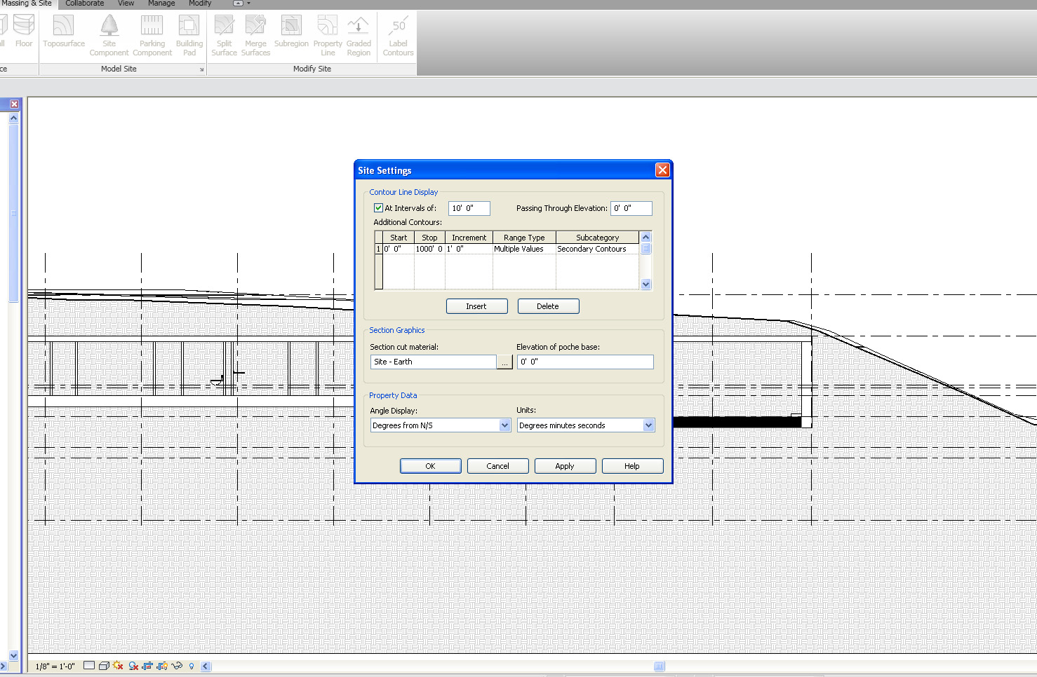
See the 2 pics I have attached. #1 shows the toolbox you led me to. I'm not seeing anything that appears to change the depth of the poche. I played with the material settings, but other than turning off the poche, I could not find a setting for altering the depth. Can you guide me a little further to it?
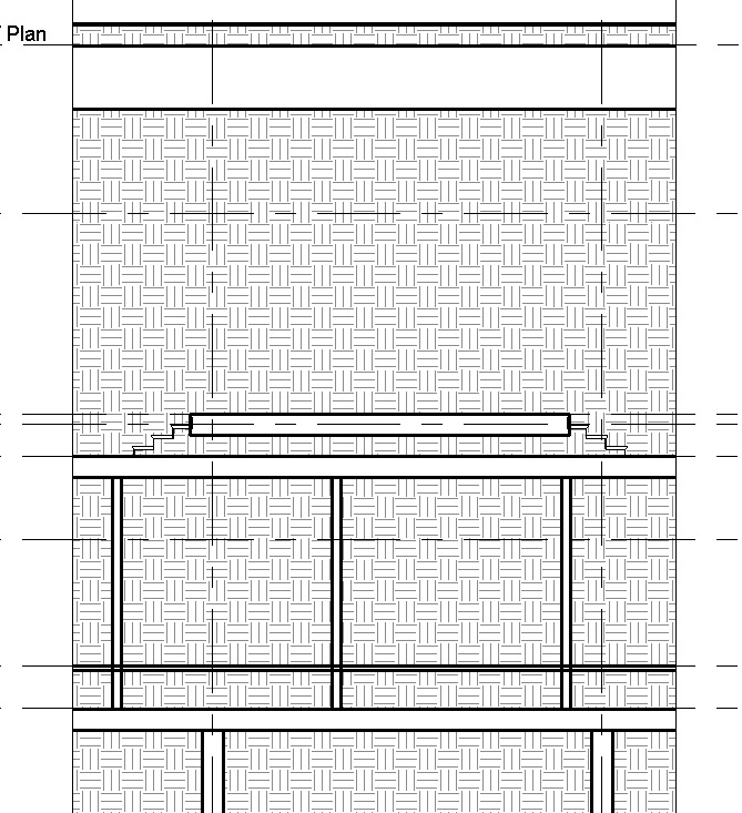
Pic #2 shows where I am right now after deleting the pad. I get the same effect if I turn off the poche. The stairs show up, but nothing in the distance, like rails, the doors in the wall, elevators, etc.
Thanks again! I feel like I am almost there. Sorry to request so much hand holding!
-----------------------------------
AECOM - Have we swallowed your firm into our collective yet? Resistance is futile. |
This user is offline |
|
|
|
site moderator|||
Joined: Tue, May 16, 2006
13079 Posts
|
Elevation of poche base......
|
This user is offline |
|
|
|
active
Joined: Tue, Sep 16, 2008
14 Posts
|
THANK YOU, WWHub!!!!!
I was using upside down logic, thinking that the poche base would be starting at the surface (0') and going downward. I didn't pick up quick enough that it was based at the model parameter base. Thank you for enlightening me!! This will make tunnels and below grade parking so much easier to display!
-----------------------------------
AECOM - Have we swallowed your firm into our collective yet? Resistance is futile. |
This user is offline |
|
|
|
Similar Threads |
|
Topo slopped pad (parking lot/road) |
Revit Building >> Technical Support
|
Mon, Aug 24, 2009 at 8:26:23 AM
|
4
|
|
Topo is struggling |
Revit Building >> Technical Support
|
Tue, Aug 15, 2006 at 9:24:01 AM
|
4
|
|
Underground House |
Revit Building >> Technical Support
|
Mon, Aug 8, 2011 at 6:54:41 PM
|
1
|
|
Topo Hatch not showing up under building pad - 2013 |
Revit Building >> Technical Support
|
Thu, Aug 13, 2020 at 5:47:10 AM
|
14
|
|
Topo surface/Building Pad problems b/w Existing and New Construction phases |
Revit Building >> Technical Support
|
Sun, Feb 6, 2011 at 12:28:27 AM
|
3
|
|
|
Site Stats
Members: | 2161655 | Objects: | 23325 | Forum Posts: | 152479 | Job Listings: | 3 |
|