|
|
|
Home | Forums |
Downloads | Gallery |
News & Articles | Resources |
Jobs | FAQ |
| Join |
Welcome !
|
88 Users Online (87 Members):
Show Users Online
- Most ever was 626 - Mon, Jan 12, 2015 at 2:00:17 PM |
Forums
|
Forums >> Revit Building >> Technical Support >> Plot color jpg image
|
|
|
active
Joined: Sat, Oct 25, 2003
411 Posts
 |
I am plotting a revit2012 drawing where i have improted a color jpg image as a background. I am plotting to a laser plotter. Previously in r2011, I can make this work by selecting the postscript version of the printer. It doesn't matter if I select raster or vector... blank page. But in r2012, all it will print is a blank page EXCEPT that it prints fine if I "print visible portion of current view". then it prints just fine, except I have to manually crop the image on the screet to fit the screen.
What's up with that?
|
This user is offline |
View Website
|
 | |
|
|
active
Joined: Sat, Oct 25, 2003
411 Posts
|
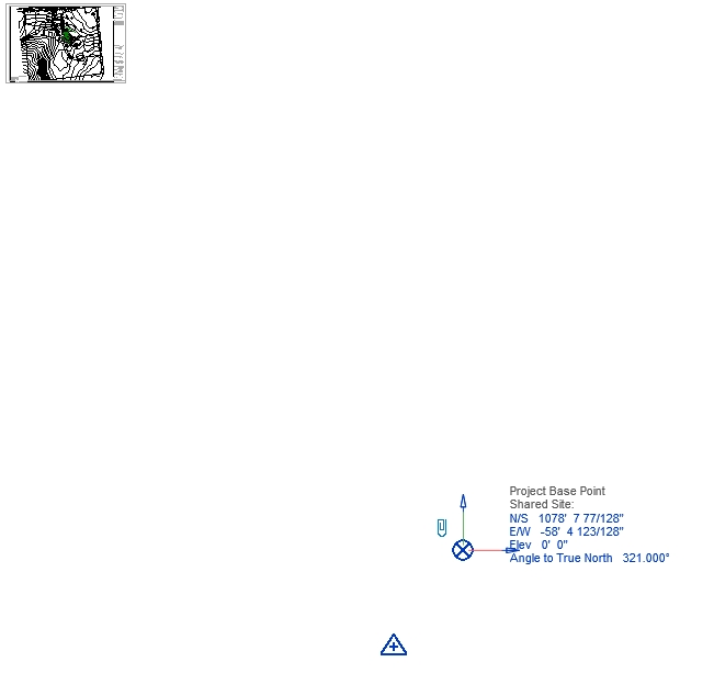
let me add a possiblity: this revit drawing contains an imported engineers site survey. attached is a screen print showing that the surveyors "project base point" is way off the sheet. Is it possible that revit is trying to print somewhere out there, and there is some setting to make it print within the limits of the revit sheet?
|
This user is offline |
View Website
|
|
|
active

Joined: Mon, Jul 13, 2009
273 Posts
 |
inside the cad, you have to center the sheet (just create a line, and in "startpoint" set 0.0.0). Most drafters draw off the axis, try to center all your drawings. Now, its a sheet with a draw on it, that means you haveto create a family for the sheet, and create a new file to create the survey. Only then you can import back the survey to revit, but make sure its on the correct elevation to every line, to use later the toposurface tool in revit.
Once you done that, you crop the view, and put it on the sheet.
Seek on the forum for "sheet creation"
Seek on the forum for "toposurface"
|
This user is offline |
|
|
|
active
Joined: Sat, Oct 25, 2003
411 Posts
|
are you saying that within autocad, the origin has to be re-set inside of the (autocad) drawing portion (in this case inside of the site plan that the surveyor has drawn)?
|
This user is offline |
View Website
|
|
|
active
Joined: Mon, Jul 13, 2009
273 Posts
|
Yes, and dont forget to match units . Since you already have a "real" origin in revit, try to match with it, from what corner or point was set as origin.
|
This user is offline |
|
|
|
Similar Threads |
|
raster image will not plot |
Revit Building >> Technical Support
|
Thu, Sep 24, 2009 at 8:43:42 AM
|
5
|
|
Plot settings with various sizes |
Revit Building >> Technical Support
|
Fri, Jan 28, 2011 at 11:29:52 AM
|
9
|
|
color plot setting |
Revit Building >> Technical Support
|
Wed, Jun 20, 2007 at 2:16:03 PM
|
0
|
|
Plot Preview in PDF |
Revit Building >> Technical Support
|
Wed, Feb 22, 2012 at 11:28:24 AM
|
4
|
|
Plot log |
Revit Building >> Technical Support
|
Thu, Feb 5, 2015 at 8:06:04 AM
|
1
|
|
|
Site Stats
Members: | 1995445 | Objects: | 22882 | Forum Posts: | 152186 | Job Listings: | 3 |
|