Forums
|
Forums >> Revit Building >> Technical Support >> toposurface problem!!!
|
|
|
active
Joined: Wed, Feb 11, 2009
4 Posts
No Rating |
Hey there, i use revit 2011, and i have a problem with the toposurface function. I imported a dwg site plan into revit, with the procedure in revit's manual, but when it generates the toposurface selecting the instance, it doesn't pick all the points in the imported drawing, just about 3/4 of the drawing. I was looking for a similar option as AutoCAD to make it select a bigger number of points but i just can't find something like that. Anyone can help me, please. Thankss
|
This user is offline |
|
 | |
|
|
site moderator|||
Joined: Tue, May 16, 2006
13079 Posts
 |
If the points are not on the layer you tell Revit to use, then Revit will not use them. Obviously the CAD file has errors. Very typical. We find that most firms using CAD are not diligent about making sure items are on the correct layer and because they rarely look at their finished work in #D, they don't see the points that are way off in elevation.
|
This user is offline |
|
|
|
active
Joined: Wed, Feb 11, 2009
4 Posts
No Rating |
hi, thank you for your help. But, I got this dwg site plan, with just the lines, (i'm sorry for my english, i'm from peru), I mean, just the "curvas de nivel", and I set the elevation of each one myself in the properties window, and i made just one layer and made sure these lines were in this layer. this is in autocad.
|
This user is offline |
|
|
|
site moderator|||
Joined: Tue, May 16, 2006
13079 Posts
|
Sorry but your last post does not match the first. In your first post, you write: "... it doesn't pick all the points in the imported drawing..." and in your last post, you write "... I got this dwg site plan, with just the lines..." Points and lines are two different things. If you do have lines, both ends of the line have to be at the same elevation.
|
This user is offline |
|
|
|
active
Joined: Wed, Feb 11, 2009
4 Posts
No Rating |
yeah yeah, sorry i made that mistake, i meant the points tha revit detect across the lines in the imported drawing.this site plan consists of 30 lines, with an elevation of 5 meters from each other. revit generates the toposurface but with just half the drawing, leaving like 10 or 15 lines.
|
This user is offline |
|
|
|
site moderator|||
Joined: Tue, May 16, 2006
13079 Posts
|
Now we have the correct question. Revit is not missing half the lines. You have not told it what to show. Under your "Massing & Site" tab, click on the down-arrow. Here is the site settings where you tell it what interval contours to display and what subcategory they will be in in VG. You can set primary and secondary contours which can give you two different line styles/weights.
|
This user is offline |
|
|
|
active
Joined: Wed, Feb 11, 2009
4 Posts
No Rating |
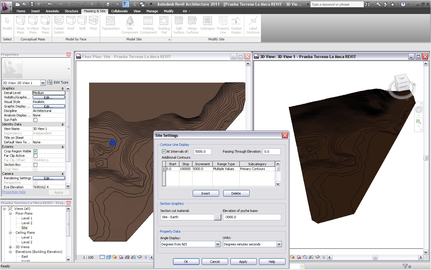
hello again, thanks for your help...i followed your instructions, and as you said revit did generate the toposurface with all the information of the imported drawing, but i can't make it show all the lines of the surface in the site plan view. I add up an screenshot so you can see it. THANKS A LOT
|
This user is offline |
|
|
|
site moderator|||
Joined: Tue, May 16, 2006
13079 Posts
|
Sorry but your screen shots don't tell me anything. Maybe you should look at the images you posted and tell us what we should be looking for. The image on the right is just a dark brown area - don't know what is is supposed to be but the image on the left looks fine.
|
This user is offline |
|
|
|
Similar Threads |
|
Toposurface problem |
Revit Building >> Technical Support
|
Thu, Feb 25, 2010 at 4:37:33 PM
|
8
|
|
Toposurface |
Revit Building >> Tips & Tricks
|
Tue, May 11, 2010 at 9:04:45 AM
|
7
|
|
A toposurface problem? |
Community >> The Studio
|
Mon, Sep 18, 2006 at 9:16:10 AM
|
4
|
|
Flat Toposurface |
Revit Building >> Technical Support
|
Thu, Aug 3, 2017 at 8:58:49 AM
|
6
|
|
Toposurface&subregion problems |
Community >> The Studio
|
Thu, Apr 16, 2009 at 1:47:06 AM
|
6
|
|
|
Site Stats
Members: | 2161655 | Objects: | 23325 | Forum Posts: | 152479 | Job Listings: | 3 |
|