Forums
|
Forums >> Revit Building >> Tips & Tricks >> Using Survey Data to create a toposurface
|
|
|
active

Joined: Tue, Nov 17, 2009
148 Posts
No Rating |
Greetings. I am having difficulty coordinating the information from my surveyor to generate a usble toposurface for my project. I have a CAD file, but it is flat. All the points are at z=0. I created a CSV file containing the survey data but I have no way to align the toposurface with the property lines / site plan. The NW and SW points were identified for me so I changed these elevations to NW = 1000 and SW = 500, thinking that I could at least orient the toposurface, but I can not accurately rotate it and align it on the property lines. Does anyone have any suggestions? (... other than inputing all the points manually)
-----------------------------------
Ian Shafer
Principal Consultant
True North S&F Consultants |
This user is offline |
View Website
|
 | |
|
|
site moderator|||
Joined: Tue, May 16, 2006
13079 Posts
 |
Have you read your HELP on how to use a CSV points file? I don't understand what you changed or why. You should be able to insert the cad file and align your points file to that.
|
This user is offline |
|
|
|
active
Joined: Tue, Nov 17, 2009
148 Posts
No Rating |
WW. As I stated, I was not the creator of the model. The model was created by the architect, with the main floor at z=0. The surveyor's cad file was just plopped down and traced, the TS in the model was manually created and then moved, by eye, down to the building ... Z=+/-0. As well, the surveyor's data does not seem to jive with the surveyor's cad file. Basically the architect created the model without any relationship to the site, topography or elevational datum. I have been asked to correct this, using the surveyors current data. So that, as the design progresses and the site is graded, we can update the model and advise the consultants accordingly. ... But I probably don't have to explain this to you. Please see the DWFx file attached ... here is the current model with the TS. I have also attached the surveyor's cad file so you can see how the 3 pieces are sitting. The model with the old TS is 'below and to the right' the current TS. I created the new TS using the survey data (the CSV file I uploaded previously) but it doesn't align with the current model. It is at the correct elevation but it is rotated. I suspect that the survey data is resulting in a 90 rotation of the TS, but without a common point, I have no way of confirming this and aligning the current Model with the correct TS. It is not my intention to leave the TS with these 2 points as they are, I simply wanted to have a 'reference' for the TS as it doesn't align with either the model or the surveyor's cad file. It's a mess and I am just trying to fix it efficiently.
-----------------------------------
Ian Shafer
Principal Consultant
True North S&F Consultants |
This user is offline |
View Website
|
|
|
active

Joined: Thu, May 28, 2009
829 Posts
 |
You did not state you were not the creator, in this thread. You posted more details on what seems to be the same problem a few days back, in that thread: ---> http://www.revitcity.com/forums.php?action=viewthread&thread_id=21683 You can copy and paste the subregion boundry lines onto your new toposurface. A pretty quick solution to discarding your old troublesome toposurface, and carrying over the aspects you like.
|
This user is offline |
|
|
|
site moderator|||
Joined: Tue, May 16, 2006
13079 Posts
|
First, for ease of use, I would create my topo surface in another file and link it into the building file (and link the building into the topo file). This allows you to move the building to the correct location with regards to the site. (Assuming that the site is correct and not the building "site". I would think the survey data is correct for true north and your project needs to rotate in relation to that. You can achieve this by rotating north in your project (and site) and your views will still be normal to your screen. In the "new" TS, I see two bad points.... I assume those are the ones you changed? In the new site model, create your site boundry using the site description - bearing and distances. This will give you the correct boundry in relation to this CSV created topography.
|
This user is offline |
|
|
|
active
Joined: Tue, Nov 17, 2009
148 Posts
No Rating |
WW, Thank you for your input, thus far. I will work with your suggestions, but I do not have the "bearing and distances" for the property lines. The property lines, like the rest of the stuff in the current model, were traced. But I had a thought ... I recall that Surveyors view angles and direction differently than Architects: - Architects establish East at 0 degrees and North at 90. Rotation = clockwise
- Surveyors establish East at 0 degrees and North at 270. Rotation = counterclockwise
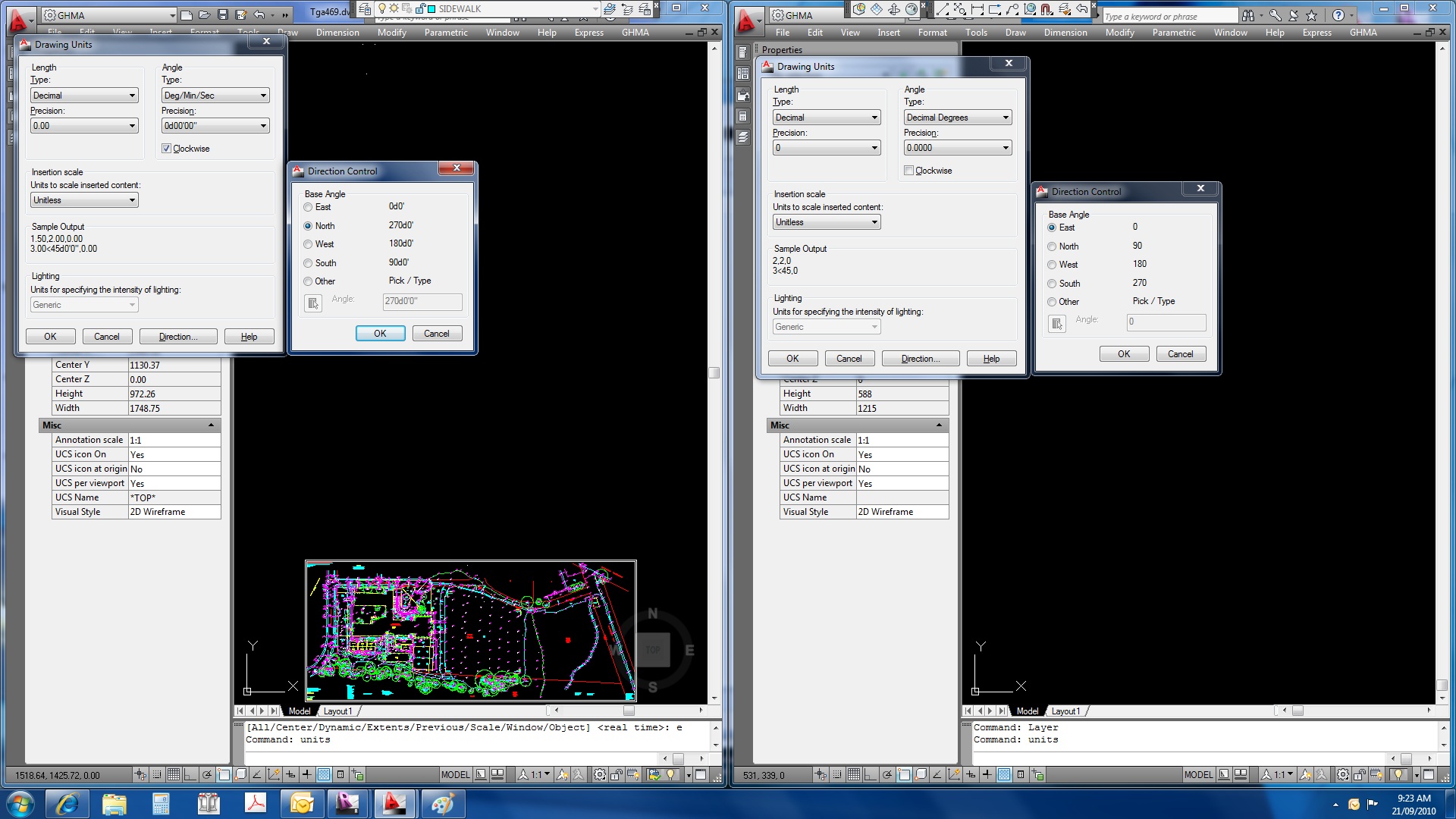
This probably explains why the imported Survey Data generates a TS that does not appear aligned with the imported CAD file ... I bet that Revit is interepretting the Survey Data correctly, but it is importing the CAD file as if the Units/Direction Control were Architectural (and not Surveyor). See the attached JPG file. On the right are the settings for the original Surveyor's CAD file, on the right are the typical architectural settings ... I think that this is the reason why my TS is not in alignment with the imported CAD file. Would you agree? If so, ... and now my brain is quite tired ... So this is what I have found: - I inserted the surveyor's cad file into the architectural enviroment.
- I rotated it -270 (90) degrees about the origin.
- I then mirrored the surveyor's cad file about the origin, AND THEN
- mirrored the surveyor's cad file using the midpoint on the West property line.
AND ... it seems to have worked. Is this what Autodesk had in mind, you think ??? Seems like there needs to be a more direct approach. If you know of one, please share. Otherwise, this is the best solution I have found.
-----------------------------------
Ian Shafer
Principal Consultant
True North S&F Consultants |
This user is offline |
View Website
|
|
|
site moderator|||
Joined: Tue, May 16, 2006
13079 Posts
|
Why are you guessing at this, the survey information needs to be correct and if it is not provided, you go back to the surveyor? You said "... I do not have the "bearing and distances" for the property lines...." - that is not true. The CAD file you initially posted clearly gives the distance and bearings. Read the "Property Lines" topic in your HELP for the process of how to enter that into Revit. BTW - Look at true north in the site drawing. Remember, true north in Revit starts out "up so when you layout your PL, it will be at a slight skew to your viewport..
|
This user is offline |
|
|
|
active
Joined: Tue, Nov 17, 2009
148 Posts
No Rating |
Thanks for everyone's input and assistance. I was able to get where I needed, with your guidances.
-----------------------------------
Ian Shafer
Principal Consultant
True North S&F Consultants |
This user is offline |
View Website
|
|
|
Similar Threads |
|
Toposurface creation using numerical data. |
Revit Building >> Technical Support
|
Fri, Oct 20, 2006 at 5:41:25 AM
|
5
|
|
help - Toposurface & model |
Revit Building >> Technical Support
|
Sat, Feb 21, 2004 at 6:33:02 PM
|
2
|
|
toposurface data import/positioning |
Revit Structure >> Technical Support
|
Fri, Dec 21, 2012 at 6:45:24 AM
|
5
|
|
Flat Toposurface |
Revit Building >> Technical Support
|
Thu, Aug 3, 2017 at 8:58:49 AM
|
6
|
|
Trouble importing AutoCAD survey into an existing buidling model |
Revit Building >> Technical Support
|
Mon, Oct 31, 2005 at 6:24:58 PM
|
3
|
|
|
Site Stats
Members: | 2161655 | Objects: | 23325 | Forum Posts: | 152479 | Job Listings: | 3 |
|