|
|
|
Home | Forums |
Downloads | Gallery |
News & Articles | Resources |
Jobs | FAQ |
| Join |
Welcome !
|
6 Users Online (4 Members):
Show Users Online
- Most ever was 626 - Mon, Jan 12, 2015 at 2:00:17 PM |
Forums
|
Forums >> Revit Building >> Technical Support >> Toposurface from Autocad File
|
|
|
active

Joined: Sun, Sep 28, 2008
20 Posts
No Rating |
Hi all Being looking at this site for a while ... time to ask a question. I know this has been done to death, but I've followed the guidelines previously outlined but can't get the result I'm after. I have a ACAD feature survey that I need o create a toposurface for Revit (Architecture 2008 version). I have gone into the original CAD file (Feature Survey Plan 02), added z values for each contour (CON_ is the contour layer) - removed unnecessary information and resaved as Feature Survey 02 ii. I have attached both files. I've then started a Toposurface in Revit 2008, imported the revised ACAD file, used the Import Insance function, nominated the CON_ layer (it lights up all the relvant points nicely), and pressed finish. All that happened was the contours got pushed up above the boundary lines ... but no contours were visible. Any help on this would be appreciated ...
|
This user is offline |
|
 | |
|
|
site moderator|||

Joined: Tue, May 22, 2007
5921 Posts
 |
Hi, and the file you use to import in Revit was the second? well, i don't know if this is what is happening because right now i don't have here Revit to check but, if you take a look at the both files and in the first (in CAD) you pick in a contour line and "LIST" you will see the "Z=43.20M" for example, and in the second file (only with contours) the "Z=4320.00", so, the units was changed and when you import this file and create the toposurface with Units=Meters, your contours go to 4300.00m TOP, then you can't see them in plan view UNLESS you create a "Elevation View" with that elevation, even in "SITE" view you can't see them because the "Top and Cut plane" by default (i think) are in 100.00m so i think this is what it's happend....
-----------------------------------
I Hope and I Wish to LEARN more, and more, and more.... REVIT |
This user is offline |
|
|
|
active

Joined: Thu, Mar 17, 2005
1231 Posts
 |
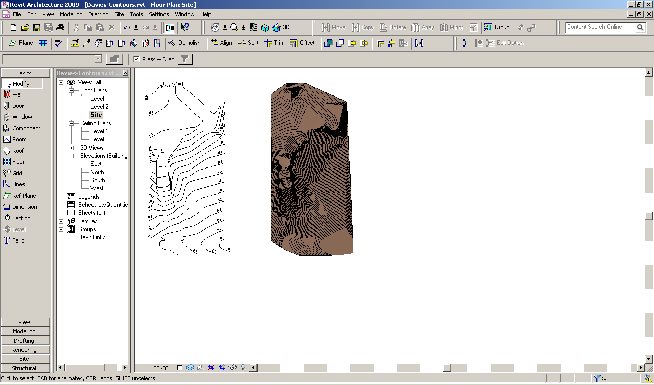
The imported dwg worked fine for me the first time thru. It creates the contours at EL. 15,000'. . I have attached an image file and the resultant rvt file as well. . I used the Auto - Position Center to Center when importing the dwg but might have had better results by using a manual option instead. Either way it still worked. I just had to look the the dwg a little by going center to center. . I had to view in 3D before I could see any of the new revit contours at first. . Then I went to a South Elevation, did a zoom to fit and meassured the offset from level 2. (15,000') . Then I went back to my site plan an adjusted the view range to have a Top Offset and Cut Plane offset of 15,000' . Have a look. . . . . . I'm having trouble uploading the resultant rvt file . . . oops it's 2.4 MB . . . not going to work as the max is 2 mb. Sorry.
Edited on: Mon, Oct 6, 2008 at 6:52:04 AM
-----------------------------------
.
FULL 'DOWNLOAD ACCESS' to all 850+ CADclips videos for only $150
|
This user is offline |
View Website
|
|
|
active
Joined: Sun, Sep 28, 2008
20 Posts
No Rating |
Thanks for the feedback. I had another shot, and changed the view to Shading with edges and could see the surface much better. It's a much more subtle gradient than I first thought.
|
This user is offline |
|
|
|
Similar Threads |
|
Flat Toposurface |
Revit Building >> Technical Support
|
Thu, Aug 3, 2017 at 8:58:49 AM
|
6
|
|
Help - How to create a Revit toposurface from AutoCAD blocks? |
Revit Building >> Technical Support
|
Thu, Aug 5, 2010 at 10:05:09 AM
|
5
|
|
A toposurface problem? |
Community >> The Studio
|
Mon, Sep 18, 2006 at 9:16:10 AM
|
4
|
|
Moving Toposurface. Imported from AutoCAD file. |
Revit Building >> Tips & Tricks
|
Tue, May 12, 2015 at 7:24:19 AM
|
1
|
|
creating a scv file in autocad to use in revit |
Community >> Newbies
|
Wed, Oct 14, 2009 at 10:24:12 AM
|
1
|
|
|
Site Stats
Members: | 2161655 | Objects: | 23325 | Forum Posts: | 152479 | Job Listings: | 3 |
|