Forums
|
Forums >> Revit Building >> Technical Support >> Pad, slab, topo, LOST!!
|
|
|
active
Joined: Tue, Jul 15, 2008
30 Posts
No Rating |
Hi, just doing a very basic single storey house in Revit Architecture 2009. my first proper attempt at doing a project on revit. Im totally lost with the site topography. ive set one up with the levels as the site slopes slightly. i have my building model basically complete, with a slab as a floor, but the only way to get rid of the topography coming through my building is with a pad?? and i have to apply a thickness and structure to the pad even though i dont actually want it, i just want to cut out area from the site topography? struggling to explain. basically im in a mess with whether i should be using pads for slabs and external paving etc. cannot find a simple walkthrough on how to set this up correctly. im guessing its simple im just missing something. appreciate any advice. thank you.
|
This user is offline |
|
 | |
|
|
site moderator|||

Joined: Tue, May 22, 2007
5921 Posts
 |
Hi, see the video and send me a feedback: http://screencast.com/t/670zZHONL
-----------------------------------
I Hope and I Wish to LEARN more, and more, and more.... REVIT |
This user is offline |
|
|
|
active
Joined: Tue, Jul 15, 2008
30 Posts
No Rating |
Thats brilliant mate thank you. i knew it would be me missing something simple. thanks for taking the time to help!
|
This user is offline |
|
|
|
site moderator|||
Joined: Tue, May 22, 2007
5921 Posts
|
You Welcome...
-----------------------------------
I Hope and I Wish to LEARN more, and more, and more.... REVIT |
This user is offline |
|
|
|
active
Joined: Wed, Apr 11, 2007
3 Posts
No Rating |
Typhoon, can you please relink your video? Thanks!
|
This user is offline |
|
|
|
site moderator|||
Joined: Tue, May 22, 2007
5921 Posts
|
Sorry, i can't re-link the video because i made that in July and i must delete some of them, because i did't have any more free space in Screencast.com, but if you have any doubt about this you can tell and i made another video for you...
Edited on: Sat, Mar 28, 2009 at 3:22:18 PM
-----------------------------------
I Hope and I Wish to LEARN more, and more, and more.... REVIT |
This user is offline |
|
|
|
active
Joined: Tue, Jan 6, 2009
2 Posts
No Rating |
Hi Typhoon, I would appreciate another video if you are able to post one. I am relatively new to Revit and am doing my first 'real' project which is a set of three townhouses on a sloping site. I am finding the Topo/Building Pad issue to be where I am most getting stuck and would love some help. I have managed to get the site topography done based on an imported CAD file, however each townhouse is set down 300mm from the next in order to follow the contours. I am wondering how to cut/split the site to match the change in levels - would the best way be to split topography or create building pads?With either option, would I need to do just one version or three i.e one building pad for all 3 townhouses or 3 separate building pads? Thanks for any help in advance!
|
This user is offline |
|
|
|
site moderator|||
Joined: Tue, May 22, 2007
5921 Posts
|
Hi, see the video: http://screencast.com/t/261gFRJWL
-----------------------------------
I Hope and I Wish to LEARN more, and more, and more.... REVIT |
This user is offline |
|
|
|
active
Joined: Tue, Jan 6, 2009
2 Posts
No Rating |
Thanks Typhoon - that looks like it will help me out a lot! I appreciate your help. Cheers.
|
This user is offline |
|
|
|
active
Joined: Tue, Mar 10, 2009
33 Posts
No Rating |
i'm lost...just don't know what sequence to take. i've imported CAD survey plan into my site plan. Went to Site/toposurface...set properties to earth material. meanwhile, i've created sea level and to simplify my exercise, i use the building slab as 0 level, above 8500 sea level. don't understand project shared coordinates. i used the property tool to copy the cad property lines. do i use this outline for the pad? i tried the parking components, how do i place it? do i place it after i create a pad? stress!
-----------------------------------
IMAC 3.06GHZ,MACOSX 10.5.6 with WINDOW XP PROF, REVIT ARCH 2009,AUTOCAD 2009,VECTORWORKS 11.0,ARCHICAD 7.0,LEED AP. |
This user is offline |
|
| |
|
|
site moderator|||
Joined: Tue, May 22, 2007
5921 Posts
|
Lilian, there are several things I don't understand: 1º "i've imported CAD survey plan into my site plan. Went to Site/toposurface...set properties to earth material." - Did you already create you surface/site in Revit???? "i've imported CAD survey plan into my site plan. Went to Site/toposurface...set properties to earth material." - Did you already create you surface/site in Revit???? 2º "i've created sea level and to simplify my exercise, i use the building slab as 0 level, above 8500 sea level." - You are working in what units??? MM, Cm, Meters, Inches, what???? so you put your slab in the "level 0" and your "sea level" is 8500 UNITS above the Level 0, OK. 3º "don't understand project shared coordinates." - Did you check in the HELP menu or in Tutorials How it Work??? 4º "i used the property tool to copy the cad property lines. do i use this outline for the pad?" - ???????? 5º "i tried the parking components, how do i place it? do i place it after i create a pad?" - YES OR you can put those components directly in the Surface, Grading..... 6º "stress!" - Don't stress, explain this questions and put some screenshots about what are you trying to do so I can figure it out and I belive someone can help you....
-----------------------------------
I Hope and I Wish to LEARN more, and more, and more.... REVIT |
This user is offline |
|
|
|
active
Joined: Tue, Mar 10, 2009
33 Posts
No Rating |
1º "i've imported CAD survey plan into my site plan. Went to Site/toposurface...set properties to earth material." - Did you already create you surface/site in Revit???? "i've imported CAD survey plan into my site plan. Went to Site/toposurface...set properties to earth material." - Did you already create you surface/site in Revit???? yes 2º "i've created sea level and to simplify my exercise, i use the building slab as 0 level, above 8500 sea level." - You are working in what units??? MM, Cm, Meters, Inches, what???? so you put your slab in the "level 0" and your "sea level" is 8500 UNITS above the Level 0, OK. mm 3º "don't understand project shared coordinates." - Did you check in the HELP menu or in Tutorials How it Work??? i read 2 books - introducing and implementing revit arch 2009 and the other introducing revit 2009 but i will try the again. 4º "i used the property tool to copy the cad property lines. do i use this outline for the pad?" - ???????? don't know what the property tool does? 5º "i tried the parking components, how do i place it? do i place it after i create a pad?" - YES OR you can put those components directly in the Surface, Grading..... maybe i cancel the topo surface and this is why the component cannot place . i will try again. 6º "stress!" - Don't stress, explain this questions and put some screenshots about what are you trying to do so I can figure it out and I belive someone can help you.... thanks for encouraging...i will try again :-)
-----------------------------------
IMAC 3.06GHZ,MACOSX 10.5.6 with WINDOW XP PROF, REVIT ARCH 2009,AUTOCAD 2009,VECTORWORKS 11.0,ARCHICAD 7.0,LEED AP. |
This user is offline |
|
|
|
active
Joined: Tue, Mar 10, 2009
33 Posts
No Rating |
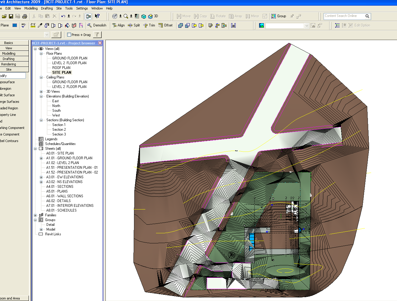
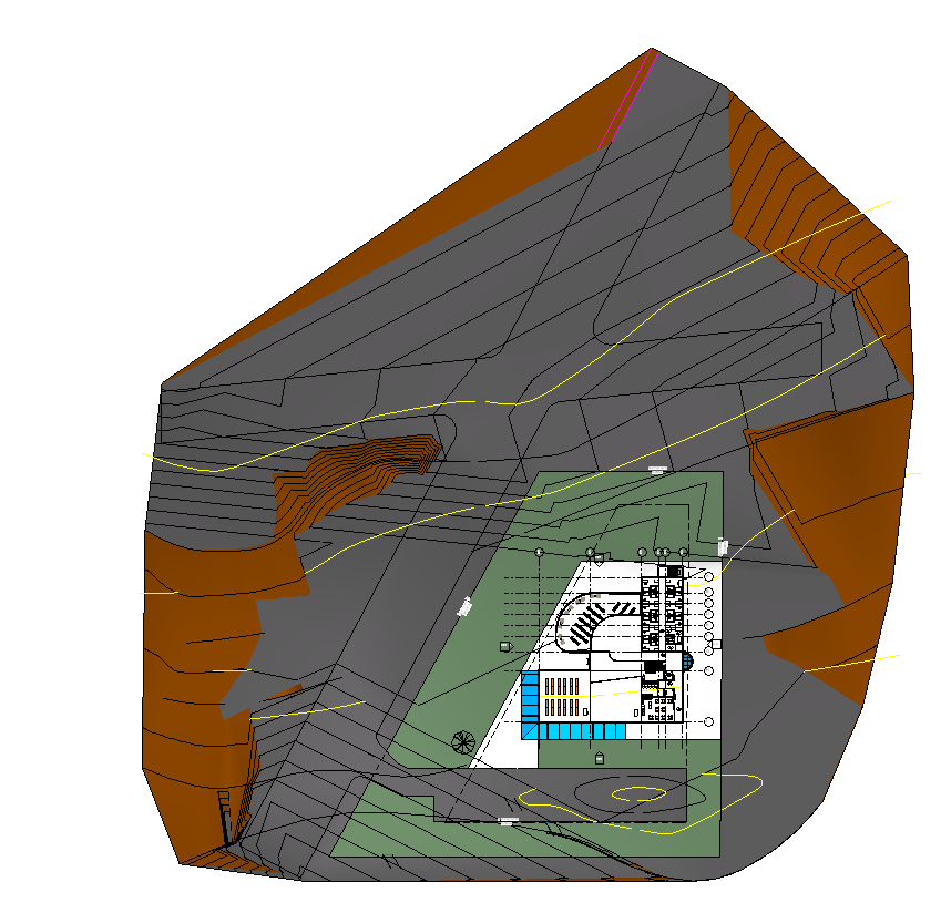
Tyhoon, here are some pictures of what i have done after going throught the tutorial createdtoposurface created subregions for roads, walkways and grass areas i've set my site plan at 0 level.the site highest contour line is 9500( mm ). i think i will have to do the pad for the building, parking and walkways so they are cut into the earth..... is this right?
-----------------------------------
IMAC 3.06GHZ,MACOSX 10.5.6 with WINDOW XP PROF, REVIT ARCH 2009,AUTOCAD 2009,VECTORWORKS 11.0,ARCHICAD 7.0,LEED AP. |
This user is offline |
|
|
|
site moderator|||
Joined: Tue, May 22, 2007
5921 Posts
|
Hi, "createdtoposurface" - Good "created subregions for roads, walkways and grass areas" - Correct "i've set my site plan at 0 level.the site highest contour line is 9500( mm )." - OK "i think i will have to do the pad for the building, parking and walkways so they are cut into the earth..... is this right?" - BINGO.... If you don't use the Pad's in your buildings (i.e.) your surfate (topo) gonna appear into the rooms, kitchen and so one, don't put thickness in the pad if you use normal slabs between the floors, for the parking and walkways remember, the PAD it's similar to a FLOOR (SLAB) so you can assign inclinations tor your PAD's if you need... OR sometimes i just use Pad around my building and the rest i change the elevation points like i want and use Subregions and if i need I "Split" the surfaces in several parts to create my final toposurface.... You must see what do you need and how do you do it... You have the tools in Revit so USE IT...
Edited on: Fri, Mar 27, 2009 at 5:20:40 AM
-----------------------------------
I Hope and I Wish to LEARN more, and more, and more.... REVIT |
This user is offline |
|
|
|
active
Joined: Tue, Mar 10, 2009
33 Posts
No Rating |
i messed up the toposurface...:-( now that the road gets into the earth. i used the grade region /toposurface/points/window delete the contour points in the parking, walkway and grassland and this is what i finally got...looks like a mess. i don't know what to do next..i'm just so tired now ..3 hours in trying to get the site level right .
-----------------------------------
IMAC 3.06GHZ,MACOSX 10.5.6 with WINDOW XP PROF, REVIT ARCH 2009,AUTOCAD 2009,VECTORWORKS 11.0,ARCHICAD 7.0,LEED AP. |
This user is offline |
|
|
|
Similar Threads |
|
Topo slopped pad (parking lot/road) |
Revit Building >> Technical Support
|
Mon, Aug 24, 2009 at 8:26:23 AM
|
4
|
|
Topo is struggling |
Revit Building >> Technical Support
|
Tue, Aug 15, 2006 at 9:24:01 AM
|
4
|
|
Topo surface/Building Pad problems b/w Existing and New Construction phases |
Revit Building >> Technical Support
|
Sun, Feb 6, 2011 at 12:28:27 AM
|
3
|
|
Building Pad |
General Discussion >> Revit Project Management
|
Mon, Jul 12, 2010 at 12:30:00 PM
|
2
|
|
SLAB AND PAD |
Community >> Newbies
|
Wed, Mar 25, 2009 at 10:46:14 PM
|
2
|
|
|
Site Stats
Members: | 1987524 | Objects: | 22875 | Forum Posts: | 152177 | Job Listings: | 3 |
|