Forums
|
Forums >> Revit Building >> Tips & Tricks >> 3D Terrain for backgrounds
|
|
|
active
Joined: Sun, Oct 23, 2005
4 Posts
 |
I have been struggling with AutoCAD for years and Revit recently to get Geo correct 3D digital terrain that looks good and is a surface. I have always worked with the SDTS DEM, NED o SRTM files with usually horrid results. They look so good in the DEM format but create such big data sets and the derived surface when I finally got one usually was mostly unmanagable. I tried the sketch up files but they are so rough and have been reduced to a simplified format and were positionally inaccurate. Last week I found a resource online that has the DEM, NED or SRTM file available as a surface already that is elevation and positon correct. The files are available indexed by state and based upon the 7.5minute USGS Quad index. File formats available are: max, dwg(contours), dwg(polymesh), dgn, rvt. The rvt(revit) file is already a toposurface. The only issue that I had was my own fault and that was that because the surface is elevation and positionally correct it was not at the normal origin for revit and I had to move the levels grid in the elevation views to where the surface or surfaces were. I just finished putting everything together works fine and looks great when you look at the building site the sky line is realistic for the location. The site I found is www.xyzresources.com
|
This user is offline |
|
 | |
|
|
active
Joined: Tue, Jun 12, 2007
5 Posts
No Rating |
Any chance you could post your model or just the 3D revit Terrian so we can see what it looks like? I am very interested in this but noticed they are 70 bucks a peice and I don't even get to download a sample of what this is like before I buy. Thanks ahead of time for any infomation you can give us.
|
This user is offline |
|
|
|
active
Joined: Sun, Oct 23, 2005
4 Posts
|
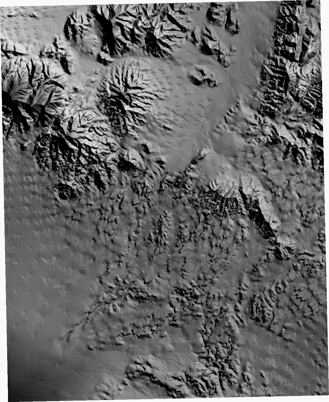
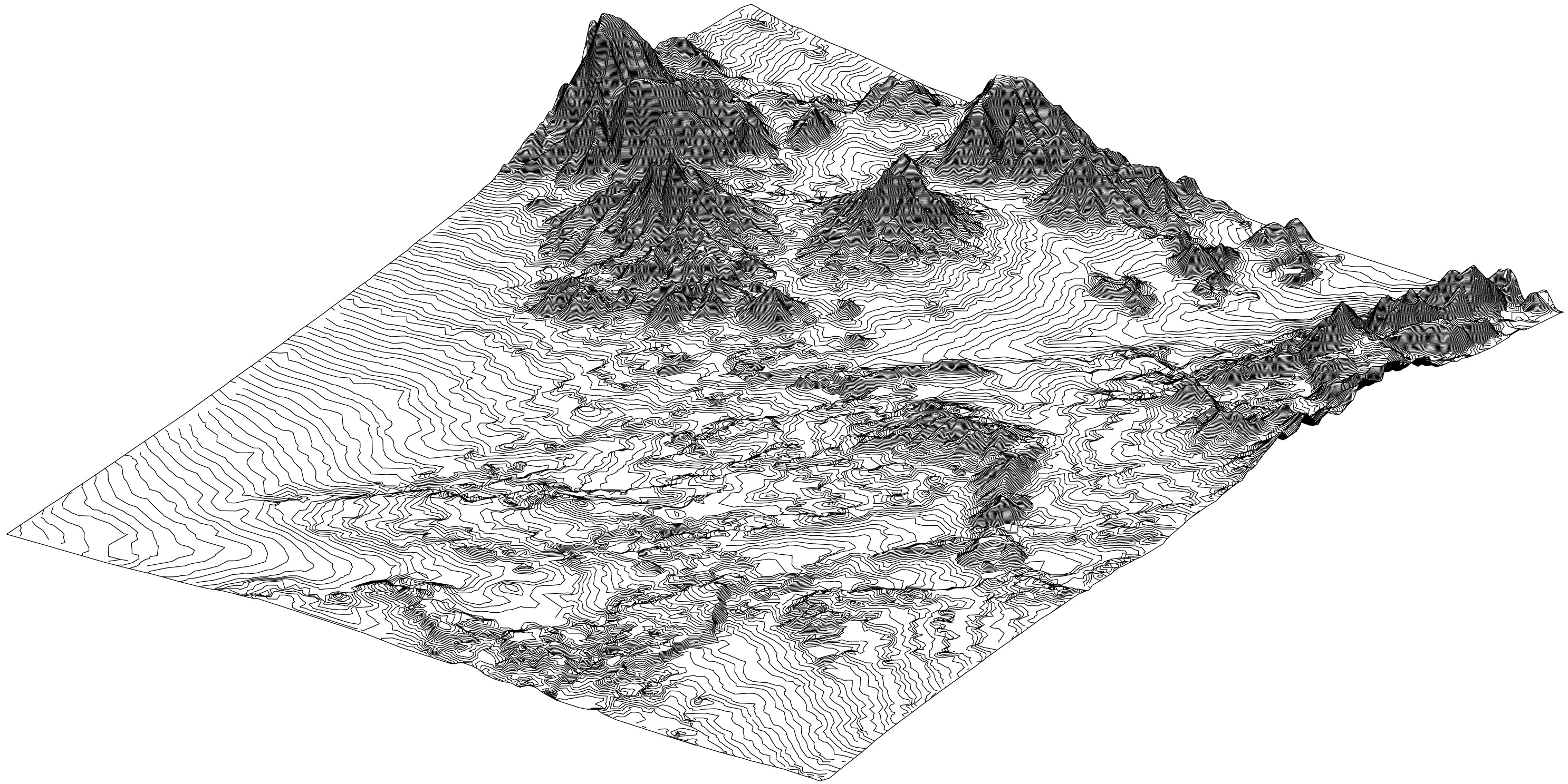
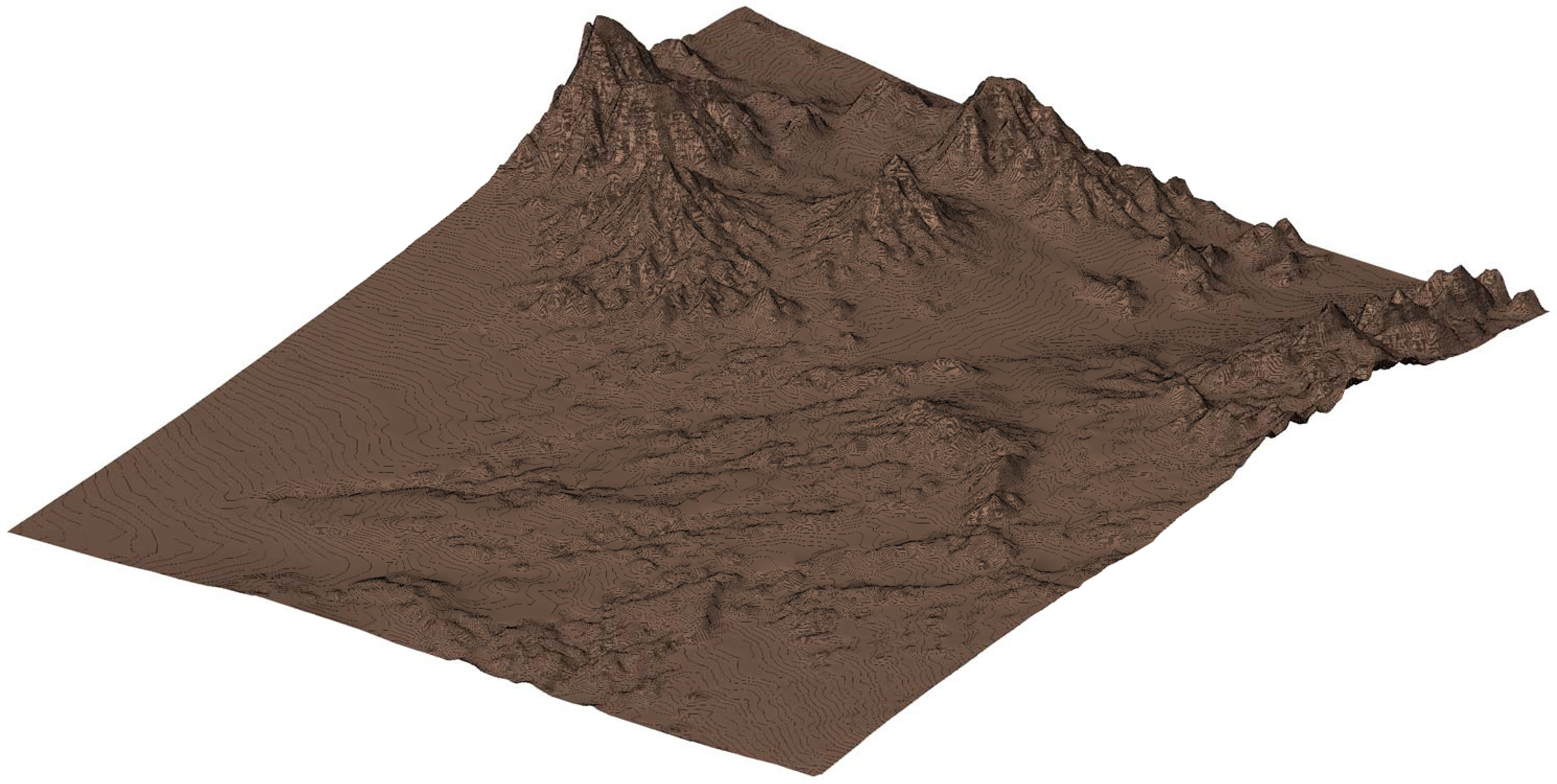
Ok here are 4 pics, of the Quad NV-APEX, I got this from them when I got the entire Las Vegas NV valley. Bear in mind that I specialize in presentations. Having an accurate background of the surrounding area had become critical if I was to compete. The NV Apex.jpg is the top down view of the Quad shaded. The NV Apex3dhid.jpg is a 3D view in Revit Arch in hidden line mode. The NV Apex3dshade.jpg is the same view in Revit Arch with Shade mode. The NV ApexPlan is a site plan view of the contours. The primary reason that I am showing this Quad is it is the one that I started with awhile back I took it from DEM to revit in about half a day and the file size in Revit was 120MB in 3D Max direct from DEM took 1.5 hour processing time and the file size was 99MB with only the terrain in. This file that I got from them is 16.6MB and is a toposurface which means (this is what I really like) I can seperate surfaces or subregion it for shade colors and render texturing with different material or colors. Also the pad command and grade region command work just fine for tweaking an area just the way I like it. As to cost, I am a one man shop and definitely on a budget but I have found that time is money. The cost of producing them on my own was at least 3 times the cost of each Quad. I joined XYZ Resources for a month and got a $20 per Quad discount for $10 and I bought multiple Quads.
|
This user is offline |
|
|
|
site moderator|||

Joined: Tue, May 22, 2007
5921 Posts
 |
Are only available for US, not from other countries, am i correct?
-----------------------------------
I Hope and I Wish to LEARN more, and more, and more.... REVIT |
This user is offline |
|
|
|
active
Joined: Sun, Oct 23, 2005
4 Posts
|
I know that many areas outside of the Continental US are available. I know Canada and Alaska and Hawaii, Mexico(I think) are available. Europe I think can be done. The price is the same, I asked. They just need the area that you want and then they will tell you yes or no.
|
This user is offline |
|
|
|
active
Joined: Tue, Jun 12, 2007
5 Posts
No Rating |
Man, Thanks a lot for posting those images...pretty sweet. So from your standpoint of view, is it worth doing this if the site is relatively flat? Also, this doesn't help if all you would see is buildings in the background, correct?...particularly on a flat site...what are you thoughts on this?
|
This user is offline |
|
|
|
active
Joined: Sun, Oct 23, 2005
4 Posts
|
I will some times add in some very generic boxy buildings if it is necessary. But the usual focus is on the project being modeled or presented. The views with the landscaping in place with the hills or mountains on the sky line in the correct proportion makes the image more presentable. I ususally have the landscaping prevalent in the imediate horizon and the mountains in the background but in the right proportions and the right location. The horizon here in Las Vegas is very distinctive and there are almost always some montains in your far horizon. Working great for me. I have kept the toposurfaces in quad form and xref them in so that I only have in model what I need for the view.
|
This user is offline |
|
|
|
Similar Threads |
|
revit terrain and roads |
General Discussion >> Revit Project Management
|
Wed, Jul 25, 2012 at 2:19:58 AM
|
4
|
|
Creating SUBREGION changes the main terrain geometry - VIDEO |
Revit Building >> Technical Support
|
Tue, Mar 13, 2012 at 12:01:55 PM
|
7
|
|
backgrounds for consultants export to dwg |
Revit Building >> Technical Support
|
Tue, Nov 22, 2016 at 7:16:16 AM
|
4
|
|
Building Pad not cutting through terrain (or cutting ALL of it!) See Pic |
Community >> Newbies
|
Mon, Apr 18, 2011 at 7:12:45 AM
|
1
|
|
roof modeling with different terrain on both face |
Revit Building >> Technical Support
|
Mon, Jan 10, 2011 at 1:37:02 AM
|
1
|
|
|
Site Stats
Members: | 1996775 | Objects: | 22885 | Forum Posts: | 152183 | Job Listings: | 3 |
|